Wednesday, January 6, 2016

Big Cool Down on the Way - But it Could Be Worse


We've gotten lucky so far this winter, with a very mild December in the books. But things will turn much colder by the end of the weekend and next week. A portion of very cold arctic air will break free from where it is typically located - the poles - and will move south into the Midwest and upper Great Lakes.

This will bring temperatures Sunday into next week into the low teens and possibly single digits for highs. Overnight lows will fall close to zero, and look for chills to be below zero as you wake up Monday morning.

While this will be very cold, and about 15-20° below our average temperature for this time of year, it could be a lot worse. Two years ago today our 'polar vortex' pattern was much colder, and persistent. January 6th 2014 saw a high temperature of -7° and a low temperature of -18°. This was just a degree away from the coldest January 6th Rockford has seen. Overall temperatures the 5th-7th in January 2014 were about 30°-40° below average! There was even a time where Rockford saw 40 consectutive hours below zero. And the chills were even worse! On the morning of January 6th 2014, the lowest wind chill recorded was -46°!

This cold snap was brought on by a few different factors. One of those, is that the Midwest saw quite a few back to back cold fronts that continued to usher in colder and colder air. The fronts would continue to establish a very cold air mass in place for the area.


We also had a large snow pack in place across the Great Lakes and Midwest region, this reinforces the cold pattern. The final piece to the puzzle relates to the very popular weather term, the 'polar vortex'. Typically in winter, it's common for a low pressure system to set up shop in southern Canada that ushers in colder air. However in 2014 a piece of the polar vortex dislodged from where it typically sits and brings even colder air into the region. It's not uncommon for a piece of the polar vortex to make it's way close to the area. What was unusual was how long it stuck around, keeping temperatures far below average for a long time. The graphic below, courtesy of the National Weather Service, shows the difference between a normal cold snap, and one due to the polar vortex. You can see a big difference between the two, with the one on the right showing a very amplified pattern that taps into arctic air. 
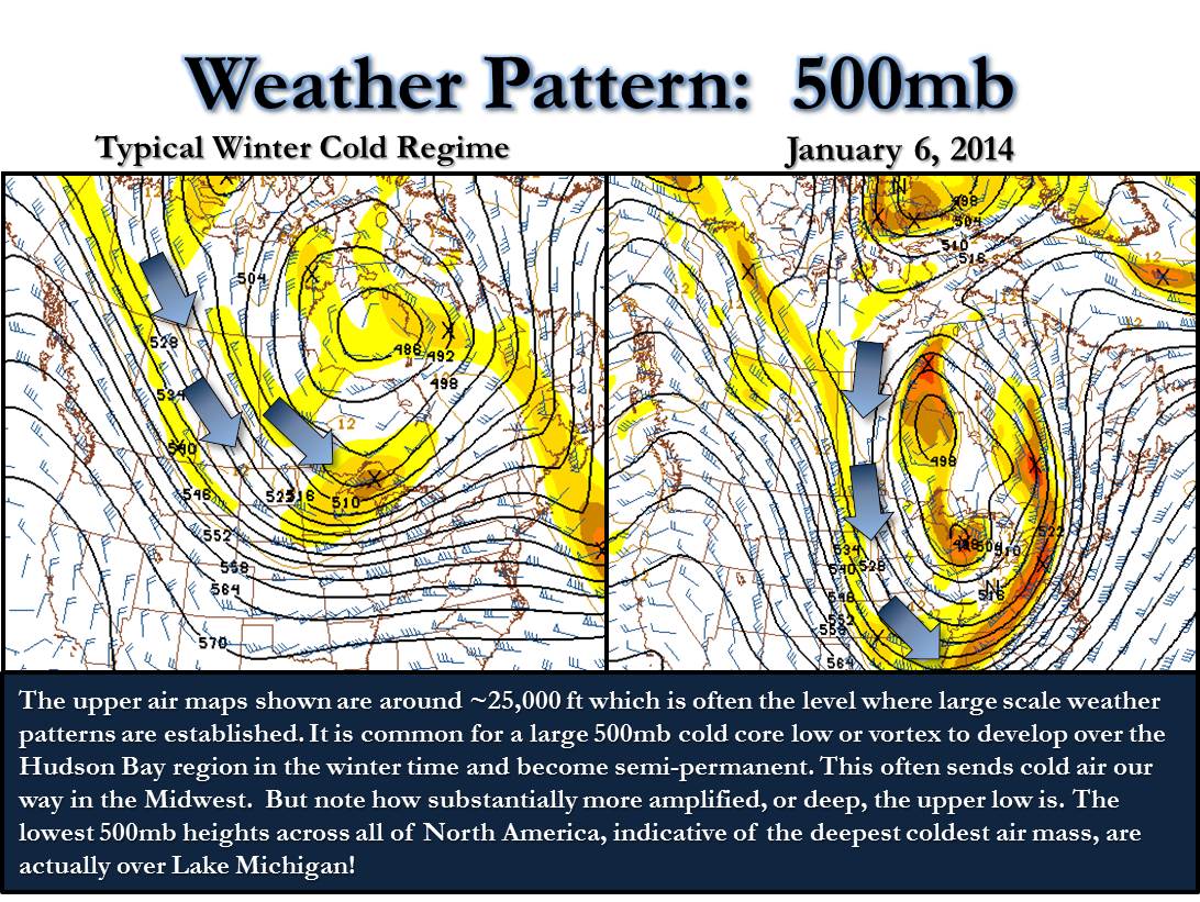
500mb Maps


While it will be quite a bit colder next week, it doesn't look to last too long. Temperatures look to return to return to more seasonable temperatures later in the month.

Tuesday, January 5, 2016

All Forms of Weather in Forecast

There are a few big stories in the weather department for the next week or so. First, we are watching a storm system that will send a few waves of energy towards the region. The first of those waves arrives Wednesday night into Thursday in the form of some light mixed precipitation--rain, sleet, snow, and freezing rain. The precipitation is expected to be very light, so any wintry accumulations will be very light, if any at all. Therefore, travel delays and school delays do not look likely for Thursday. Temperatures on Thursday will warm into the middle 30's by the early afternoon, which will allow any precipitation that falls to fall as plain rain. Again, the precipitation on Thursday will be very light.

The second wave arrives Friday and that will be associated with a stronger low pressure system surging northeastward from Oklahoma and Arkansas. There will be more moisture available for that system to work with. Thus, more precipitation will fall. Everything will fall as rain on Friday with high temperatures in the upper 30's. By the time Saturday morning arrives, a good half-inch to three-quarters of an inch of rain appears like a good bet for the entire region. The rain will likely be steady, but mainly light. Occasional moderate rain is possible on Friday. That wave of energy will move out Saturday, but as colder air wraps in Saturday, the lingering light precipitation will fall as a rain shower-snow shower mix, or just as plain light snow showers. As with the first wave of precipitation, the wintry precipitation with the second wave will not really accumulate.

The next big story is the very cold air that will filter on into the region late in the weekend into next week. As a blocking high pressure system sets up over Greenland, much colder air will finally be allowed to plunge southward into the Midwest, Great Lakes, and Northern Plains, something we haven't seen much of this winter thus far.
This will be arctic air, and the coldest air we have seen thus far this season. In fact, we are looking at a stretch of days beginning Sunday and lasting through the middle of next week with high temperatures likely remaining in the teens, if not slightly colder. Low temperatures will drop into the lower single digits to near zero, if not below zero for a few nights next week. The map to the right shows the coldest we will likely get next week. The heart of the arctic air looks to remain to our north and northwest, but temperatures could drop as low as -5°, especially in Jo Daviess, Stephenson, Green, and Rock Counties early next week.

A second influx of very cold air looks possible later in the January as well after a slight moderation occurs late next week.


Monday, January 4, 2016

Late Week Warmth Comes With A Little Wintry Mess

Before we get to the rain, we may have to deal with a mix of snow, sleet and freezing rain as early as Wednesday night.  It won't be much, but could be just enough to cause some problems for the commute Thursday morning.  This is when temperatures will be slightly below freezing (32 degrees). 

As warmer air and a little more moisture are pulled north ahead of the low, surface temperatures should rise above freezing switching any wintry precipitation over to rain.  Light rain showers will likely persist into Thursday night with a little more steady rain falling for Friday.  Temperatures Friday will warm into the upper 30's in northern Illinois, middle to upper 30's in southern Wisconsin.

The center of the low will pass overhead Friday night with colder air wrapping back in for Saturday.  This means our low Friday night and our high Saturday morning will be nearly the same, with temperatures dropping by Saturday evening.  If the low tracks a little further to our south Friday evening/night, we could see a transition back over to a mix before the lighter snow Saturday.  Something to keep in mind as we get closer to the end of the week.  A much colder air mass moves in late in the weekend and into next week.  You can read more about that in Meteorologist Tyler Sebree's blog post below.

Arctic Air Aiming at Stateline


It has been a mild winter thus far across Northern Illinois and Southern Wisconsin as a strong El NiƱo has been present. However, there is a slight blip in the road setting up for next week in the form of very cold air from Canada. This will likely be the coldest air of the season, and it will last for several days before we likely return to slightly milder temperatures. On the map to the left, the blues and greens are indicative of where the forecast models believe colder than average temperatures will be from January 9th thru 14th. This particular map only shows that time frame, but the colder air will likely hold on until the 18th-20th. This arctic air will plunge south behind the storm system that will affect the region late this week into Saturday.

The reasons behind the upcoming stretch of cold air boil down to a few things, but the most important are two factors that meteorologists look at to determine temperature patterns switching from positive to negative. The graph to the right shows what is called the Arctic Oscillation (AO). Notice the trend from positive (above the black line in the middle) to negative as we head into January. That is highly correlated with temperatures that are colder and below average.

The other variable meteorologists look at is referred to as the North Atlantic Oscillation (NAO). The same trend can be noticed here. The values were positive during December, but they are expected to continue diving negative as we head through January. Again, much like that AO, a negative NAO value usually points to colder weather for the Eastern United States. An important question that cannot be answered quite yet is: "Just how cold will it get?"

At this time, putting specific numbers out there just isn't feasible due to the likelihood that things will shift around a little bit once the models grasp a better idea of what will happen. However, high temperatures in the teens--even lower teens--and low temperatures in the single digits to near zero are looking increasingly likely.

Sunday, January 3, 2016

Gaining Sunlight

If you're like me, you've noticed the sun setting a little later each and every night since the winter solstice.  And on cloudy days like today, that's something to look forward to.

Each day through the end of the month, we're gaining about a minute of daylight in the evening!  And by the middle of January, we'll be gaining a couple minutes each day in the morning.

The sunrise Sunday morning was at 7:25am and the sunset set at 4:36pm.  By the end of the month, the sun will rise at 7:11am and set at 5:09pm!  So, even on these grey, cloudy afternoons there is something to look forward to.

Saturday, January 2, 2016

Next Chance of Precipitation

We have seen a dry pattern establish itself across the Midwest, Great Lakes, and Northern Plains of late. No significant systems have moved through in several days, and that trend will likely continue for nearly one more week before a break down in that pattern occurs. More clouds are expected on Sunday with lake-effect snow for Chicago and Northern Indiana. That moisture is a result of northerly winds over Lake Michigan, which can lead to the formation of lake-effect snow showers. Those will stay to our east on Sunday and Monday. The clouds will move out for Monday and Tuesday with high pressure moving overhead. That will keep our skies mostly sunny.

Our winds shift around to southwesterly as the high pressure center moves to the east for Wednesday and Thursday. The high moving east will also open up the middle of the country for cyclone formation, or the development of a storm system. It will also allow moisture to stream northward from the Gulf of Mexico to feed into any low pressure system that does in fact develop. Models are suggesting a low pressure center will develop in Southern Colorado and Kansas on Tuesday before moving northeast towards the Stateline on Thursday and more so Friday.

It will tap into the moisture bank that is the Gulf of Mexico and bring a decent amount of rainfall to the region. Most of our precipitation will fall on Friday and Friday night as it looks currently. The reason why we are looking at mainly a rain event is because the low will strengthen enough to draw enough warm air northward to warm our temperatures into the middle 30's and possibly low 40's while the heaviest of the precipitation is falling. It is not impossible to see some snow showers to begin the event on Thursday and Thursday night. Snow showers are also possible to end the event Saturday morning, but little to no accumulation is expected in the snowfall department as it looks now.

Friday, January 1, 2016

A Look Back at the Record Warmth/Cold and Precipitation During 2015

Welcome to 2016!  It's not only starting to look like winter, but it's beginning to feel like it as well.  The big question is, though, just how long winter's chill will last?  While we'll see a return of seasonable temperatures by the middle of next week, we could be in for quite a chill towards the middle of the month.  More on that in a later post, but let's look back to the records that were set in 2015!

According to the National Weather Service, the average high temperature in Rockford for 2015 was 59.5 degrees.  This was 0.2 degrees above the 30 year average (1981-2010) which is 59.3 degrees.  A total of 40 inches of precipitation was recorded during the year, which is 3.76 inches above normal!

Here's a month-by-month look at what records were set during 2015:

January - No records set

February:
-Record daily lowest maximum temperature of 4 degrees on the 19th
-Record daily lowest maximum temperature of 9 degrees on the 23rd
-Record daily low minimum temperature of -8 degrees on the 26th
-Tied record daily low minimum temperature of -15 degrees on the 27th
-Record daily lowest maximum temperature of 12 degrees on the 27th
-Record daily low minimum temperature of -16 degrees on the 28th
-Second coldest February on record since 1906 at 12.1 degrees

March:
-Record daily lowest maximum temperature of 13 degrees on the 5th
-Record daily snowfall of 5.1 inches on the 23rd

April:
-Record daily precipitation of 2.24" on the 9th

May:
-Record daily snowfall of a trace on the 20th
-Record daily lowest maximum temperature of 47 degrees on the 20th

June - No records set

July - No records set

August:
-Record daily precipitation of 2.87 inches on the 18th
-Record daily precipitation of 1.42" on the 29th

September:
-Third warmest September on record since 1905 at 69.1 degrees

October - No records set

November:
-Record daily highest minimum temperature of 58 degrees on the 5th
-Maximum daily snowfall of 4.9 inches on the 20th
-Maximum daily snowfall of 3.9 inches on the 21st
-Maximum daily rainfall record of 1.51 inches on the 26th
-Record daily rainfall for the Thanksgiving Holiday of 1.51"

December:
-Tied daily maximum temperature of 57 degrees on the 10th
-Record daily highest minimum temperature of 46 degrees on the 12th
-Record daily maximum temperature of 62 degrees on the 13th
-Record daily maximum precipitation of 1.41 inches on the 13th
-Record daily maximum temperature of 61 degrees on the 14th
-Record daily minimum temperature of 41 degrees on the 14th
-Record daily precipitation of 0.63 inches on the 21st
-Record daily maximum temperature of 59 degrees on the 23rd
-Record daily precipitation of 0.70 inches on the 23rd
-Record daily precipitation of 1.25 inches on the 28h
WARMEST DECEMBER ON RECORD SINCE 1905 WITH 37.7 DEGREES
SECOND WETTEST DECEMBER ON RECORD SINCE 1905 WITH 4.65"