Thursday, March 30, 2023

Growing concerns for severe weather Friday afternoon and evening


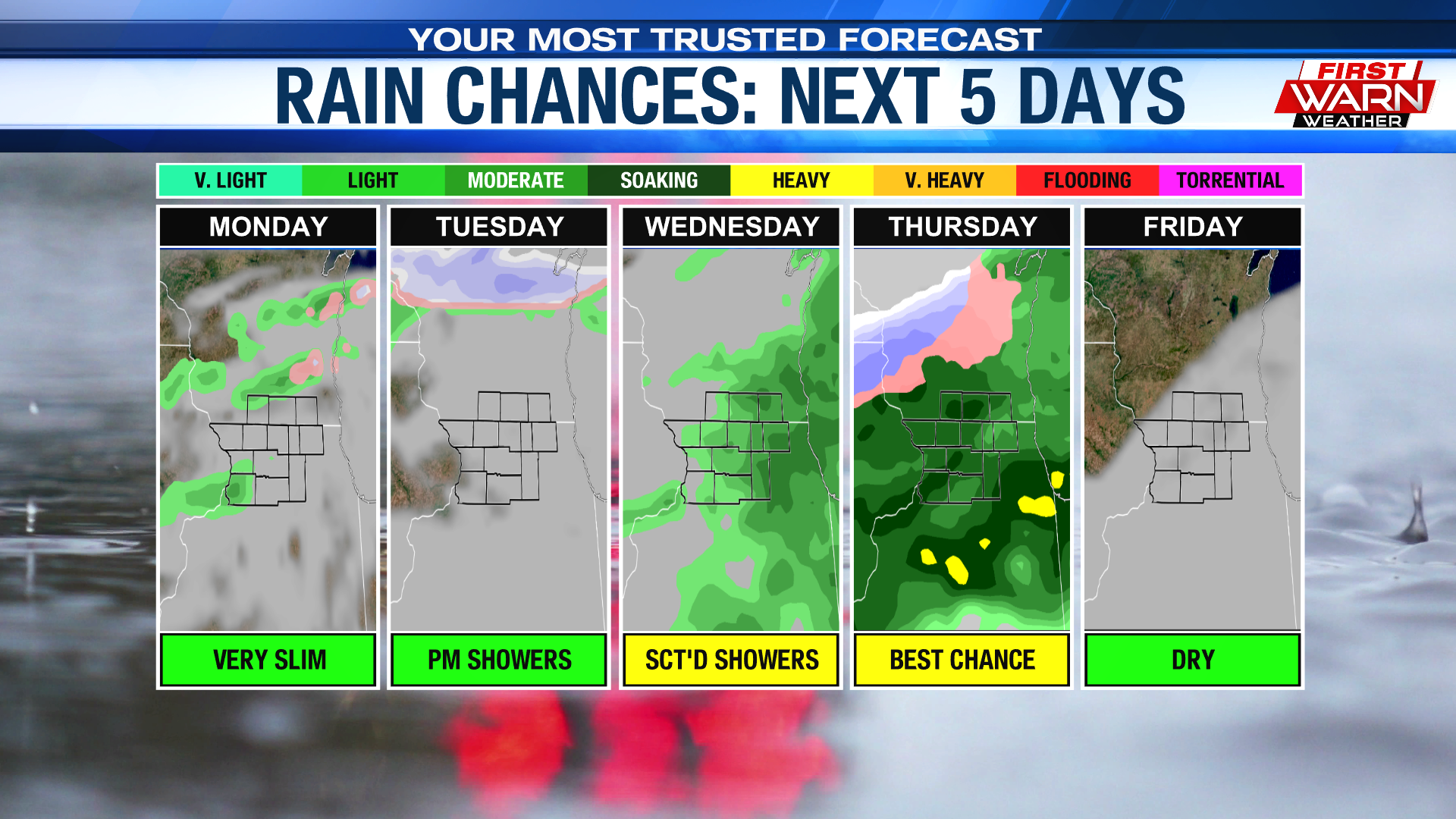
The threat for severe thunderstorms Friday afternoon and evening continues to grow as a large storm system moves across the Midwest. Damaging winds, hail, and tornadoes are all possible for northern Illinois and southern Wisconsin. However, there is a slightly higher risk for tornadoes west of I-39.

Skies remain cloudy Thursday evening as a warm front moves in from the south. Showers and mixed precipitation have developed along the leading edge of warm air aloft, moving through Minnesota and central Wisconsin. We may see a sprinkle or two during the evening, but isolated thunderstorms are likely after Midnight. Severe weather is not expected with those storms, but a few of the stronger ones may produce some small hail. Those storms will be weakening/fading by Friday morning, with a chance for a few scattered showers going into Friday morning.

Two rounds of thunderstorms are possible Friday, one for the early afternoon and then another late afternoon and evening. The first round is forecast to form along a weakly organized upper-level low. Our atmosphere is capped, meaning it has a lid on it, during that time. This would cause those storms to become elevated giving us a hail and gusty wind threat. If, however, that cap weakens or breaks then the risk for those storms to become severe would increase, producing a slightly bigger hail and wind threat. The window for those storms to move in is from 1-3pm.


The second round of thunderstorms pose more of a severe threat, assuming the first round clears out fast enough. These storms will initially develop in Iowa ahead of low pressure and a cold front, quickly turning severe early afternoon. As the storms move east, they'll develop into a line crossing into northwest Illinois. There is a risk that a few isolated storm cells remain detached from this main line. If that occurs damaging winds and isolated tornadoes would increase. The greatest threat for that remains west of I-39.


The damaging wind threat will increase as the line of storms move east across northern Illinois and southern Wisconsin. The timeline for this second round is roughly from 4pm to 10pm.  


Once the storms move out winds will increase quickly behind the departing low pressure system. Cold air will rush in behind bringing temperatures down into the 30s through Saturday morning. Scattered snow showers are possible early Saturday with drier skies for the afternoon.


Please make sure to have multiple ways to receive watches and warnings Friday and know where to seek shelter should severe weather occur. Plan today, be ready to act tomorrow. Storms will be quickly moving from the southwest to northeast between 50-60 mph.  This will not give you a lot of time to react when a warning is issued.  Updates will continue regarding the severe potential, so be sure to keep checking back.   

Wednesday, March 29, 2023

Severe storm threat continues for Friday


The first severe weather event remains well in play for the Stateline as the threat for severe thunderstorms increases late Friday afternoon and evening. All hazards of severe weather: damaging winds, large hail, and isolated tornadoes are possible during that time.

Skies will turn partly cloudy Wednesday evening as high pressure slides to the east of the Stateline. Light winds and mostly clear skies will allow temperatures to dip into the 20s overnight. Winds will quickly turn to the southeast during the day Thursday warming temperatures through the 40s, then into the 50s by the evening. A few showers are possible along the leading edge of the warm air, passing through northern Illinois and southern Wisconsin mid-afternoon.


Winds will increase Thursday night as the low-level jet moves in from the southwest. This, along with a slight increase in instability, will likely cause a few isolated thunderstorms to develop overnight. Some of the stronger storms may produce small hail.

Scattered shower activity may continue throughout the day Friday as temperatures warm through the low to mid 60s. It doesn't appear that we will completely clear out, but any breaks in the clouds could cause temperatures to warm even further. It may also feel muggy during that time as dew point temperatures are forecast to rise into the 50s!

The entire Stateline is under some sort of risk for severe weather Friday evening, with a slightly higher risk west of I-39. Thunderstorms are expected to develop in Iowa during the afternoon, starting off as discrete supercell storms capable of damaging winds, large hail and tornadoes. As the cold front moves east, the storms will most likely grow into a linear structure posing a damaging wind threat into Illinois. However, there is a chance that isolated tornadoes could occur within this line. And that threat is higher if individual storm cells remain outside of the line of storms. 


While the ingredients for severe weather are coming into better play, there are some limiting factors. Cloud cover and rain showers during the afternoon Friday could continue to lower the needed instability for severe weather to move east into the Stateline. It's also possible that moisture remains low locally, and higher to the south, taking away some of the fuel needed for storm development. But even though the severe threat isn't a done deal, it's important to remain weather
aware the next couple of days. Make sure you are staying up to date with the forecast, have a plan in place should severe weather occur, and have multiple ways to receive warnings. Updated weather information will continue leading into Friday.  

Monday, March 27, 2023

Light snow returns Wednesday morning


Snow continued to melt away Monday afternoon as temperatures warmed into the middle and upper 40s. Mostly clear skies will prevail through Monday evening, but cloud cover will slowly increase through the night. Overnight temperatures will fall into the mid 20s.

Tuesday will start off mostly cloudy, but we should see a little more sunshine for the afternoon. Highs will warm back into the upper 40s, to right around 50

degrees. A second cold front will begin to sink south Tuesday night, crossing the Stateline Wednesday morning. This will result in the development of light snow during the morning.

Any accumulations are expected to remain minor, but an increasing northwest wind could cause some issues with visibility, especially during the morning commute. Northwest winds will gust around 20-25 mph holding temperatures in the upper 30s during the afternoon.  

Sunday, March 26, 2023

Isolated thunderstorms Sunday evening


A quick moving low-pressure system has been responsible for scattered showers and isolated thunderstorms across northern Illinois and southern Wisconsin. Severe thunderstorms developed outside of the area and are currently moving towards northwest Indiana. Severe thunderstorms are not expected for the Stateline, but the elevated thunderstorms have produced pea sized hail.

The showers and storms may mix in with a few snow

showers through sunset, with all precipitation coming to an end before 10pm. Minor accumulations are possible with any of the snow, should it hold together as it moves east. Greatest threat area would be along and north of Highway 20.

Temperatures during the afternoon warmed into the mid/upper 30s, to upper 40s/low 50s across the Stateline. The warmer temperatures were realized where the snow has completely melted, while the cooler temperatures remained over southwest

Wisconsin and northwest Illinois. Under a partly cloudy sky Sunday night, overnight lows will dip into the upper 20s.

Thursday, March 23, 2023

Drying Out Early, Accumulating Snow Possible Into Saturday

Drying Out Early:

A cold front sweeping through the region has brought a round of scattered showers into the area ahead of the morning commute. With cold air surging in behind it, areas to the north are waking up to either a wintry mix or to heavy snow. 

For the most part, this morning's activity will fall in the form of rain. However, it wouldn't surprise me if we managed to squeeze in a few wet snowflakes in some of our cooler spots. All in all, amounts will end up at a tenth of an inch or less, with chances fully coming to an close by mid-morning. The rest of the daylight hours will remain dry under a mostly cloudy sky. With winds shifting to the north and northeast, high temperatures will end up only peaking in the low to mid 40s.

Active Stretch Ahead:

Beyond today's chances, we've got quite the active stretch, including the potential for accumulating snow Friday night into Saturday. 

Most of Friday remains dry, with clouds increasing late in the day. Similar to today, a cooler east to northeast wind will place highs below the 50-degree mark. Forecast models then show our next storm system swinging in from the southern plains, landing somewhere in between N. Illinois and NE. Indiana by Saturday morning. So right off the bat, you can see that guidance doesn't really have a firm grip on the storm's track. However, precipitation type remains on track with this event beginning as a mix of rain and snow Friday evening/night.

Early Weekend Snow?:

A meteorological process known as dynamic cooling with help with the transition to wet snow as we head into early Saturday. At this moment in time, it’s a bit too early to speculate on the "how much" factor, especially with the difference in the storm's overall track this morning. 

But he likelihood for accumulating snow has been slowly increasing with each passing day. Along with the wet snow comes a rather gusty wind out of the northeast at first, then out of the northwest. Highs because of this wind will end up even cooler than today and tomorrow, with most struggling to make it out of the 30s. Clouds will decrease into Sunday, bringing the chance for mixed sunshine into the afternoon. But this break from the active pattern is short-lived as another storm system takes aim at the Stateline early next week.

Wednesday, March 22, 2023

Rain Arrives Late, Low Severe Risk into Early Thursday

Rain Arrives Late:

Ahead of our next cold front, winds are expected to remain warm out of the south/southwest. This will help bring temperatures into the 50s for the 3rd straight day, with most peaking in the low 50s. Dry conditions this morning will eventually lead to our next rain opportunity, which looks to commence sometime after mid-day. The nature of today's rain will be light and scattered at first, becoming more numerous this evening and overnight. There is the potential for an isolated thunderstorm or two during the latter half of the day. But the better potential for thunderstorms moves in early Thursday, some of which could wind up severe.

Low Severe Risk:

The early-morning outlook from the Storm Prediction Center has a Marginal Risk (level 1 of 5) from I-80 south into central Illinois. Small-sized hail will be the biggest of the concerns with any thunderstorm that is placed under a severe thunderstorm warning. 

Even though we are placed under the "general" thunderstorm category, it wouldn't surprise me if we had the low chance for a strong storm or two. As we say with every severe threat, it's important to remember to have multiple ways to get watches and warnings. Just in case. In the end, totals should range between .25"-.50". Forecast models bring said cold front through shortly before sunrise, with precipitation coming to a close shortly after.

Drying Out Thursday:

The rest of our Thursday will be spent under a mostly cloudy sky. Thanks to the early-morning frontal passage, winds throughout the day will be more out of the north and northeast. 

This will cool our high temperatures for the second half of the work week, with most peaking in the low to mid 40s Thursday. Friday starts off dry, with the potential for a wintry mix and even wet snow increasing into Friday night. Confidence is low at this moment in time, but it's definitely something we'll have to keep an eye on.

Tuesday, March 21, 2023

Few Showers Late, Better Rain Chances Wednesday into Thursday

Spring-Like Warmth:

In my opinion, mother nature brought the right dose of weather to ring in Astronomical Spring. To recap, Rockford registered a high of 53° under a mix of clouds and sun. A significant improvement as the Stateline was sitting in the bitterly cold 20s just two days prior. Looking ahead, we do have a few more days with highs in the 50s. However, the closer and closer we get to the weekend, the more active our weather pattern will get. 

Few Showers Late:

The best chance for sun today will during the early portions of the morning. As we inch closer to the mid-day hours, the Stateline will once again be sitting under a mostly cloudy sky. Despite today's cloud cover, the low to mid 30s that we wake up to will provide a warm enough start for temperatures to peak in low 50s this afternoon. 

It also helps that our winds will be blowing out of a south and southeast during peak heating hours (11AM-4PM). In a similar fashion to Monday, a sprinkle or two can’t be entirely ruled out. But most of the day should remain dry. 

Towards the end of the evening commute, a round of scattered showers will develop, with chances likely lasting into the first half of the night. As the low responsible for these showers pulls away, conditions will dry out but remain mostly cloudy into Wednesday. Temperatures will end up slightly warmer, landing in the upper 30s.

Active Pattern Continues:

The best chance for rain moves in late in the afternoon Wednesday as a cold front approaches from the west and northwest. Once rain begins to fall, it will likely last into Wednesday night and even into the early portion of Thursday. 

Forecast models then show this boundary stalling across central Illinois, placing the region under a chilly northeast regime. This will likely bring down our temperatures for the late-week days, with highs both Thursday and Friday peaking in the mid to upper 40s. Temperatures over the weekend will all depend on the track that a secondary storm system takes across the Midwest. Same with the type of precipitation we'll see, especially Friday night into Saturday.

Monday, March 20, 2023

Long stretch of record warmth in March 2012


We are coming to the end of what was a long stretch of record warmth back in March 2012. Numerous record high temperatures were recorded as readings soared through the upper 70s and low 80s. In fact, eight record high temperatures were recorded that year, stretching from March 14th through the 22nd. The only day during that stretch of warmth that didn't record a record high temperature in 2012 was March 19th, but it was close!

The month also started what would ultimately end up being a hot and dry spring and summer. July also recorded several triple digit record high temperature readings from July 4th through the 7th. Extreme drought conditions developed across northern Illinois by summer, leading to quite a bit of stress on the crops in the region. But it wasn't just the Stateline that experienced those drought conditions that year. Much of the Midwest and Great Plains were also dealing with either extreme or exceptional drought, which carried over into the following year. 

First Day of Spring, Multiple Rain Chances Ahead

Welcome to Spring!:

It's the day that many, including myself, look forward to the moment we switch into the winter season, the day of the Vernal Equinox! 

To recap, this is the point in the Earth's trip around the sun where the center of the sun's rays are directly focused above the equator, bringing us roughly 12 hours of day and night. 

Today's sunrise will be around 6:59AM, with the sunset happening at 7:08PM! While a majority of winter featured more above-average days than seasonable or below-average days, winter did give us a run for his money over the last two weeks. So much so that Rockford observed it's highest daily snowfall total for the season back on March 9th, picking up 6.8". Similar accumulations were observed to our north and west. We also saw a rather cold northwest wind restrict high temperatures to the mid 20s this past Saturday. But thankfully the wintry chill from this past weekend won't be sticking around as we make the seasonal change!

Seasonable Start:

Monday kicks off with partial sunshine, with clouds increasing into the afternoon. This is all in response to a weak frontal boundary that parks itself to the north across SE. WI. 

With the Stateline being located south of the front, winds will breezy but out of the southwest. Temperatures because of this will be able to climb to seasonable levels, with most landing in the upper 40s. Along with the cloud cover, a few sprinkles can’t be entirely ruled out Monday afternoon. The cloud cover and the chance for sprinkles lingers into the overnight hours, with temperatures falling into the low 30s. A secondary chance for scattered showers arrives Tuesday, with highs climbing into the low 50s.

Active Stretch Returns:

During the Wednesday and Thursday time frame, forecast models show a big dip in the jet stream to the west of the Rockies. N. IL and S. WI will be placed on the eastern side of the dip or trough, right under the stronger wind flow. 

At the same time, a rather strong frontal boundary is shown sliding through the region, stalling out just to the south of Interstate 80. Now, it should be known that the position of said boundary could change over the next 1-2 days. But depending on where that boundary ends up will determine if we trend upwards or downwards with our temperatures and also when and where the heaviest rain will fall. For now, we have temperatures climbing into the low 50s ahead of the frontal passage, then sinking back down into the upper 40s both Thursday and Friday.  

Rainfall-wise, it seems the best opportunity will be pushing through Wednesday night into Thursday. Friday will be a bit drier as an area of high pressure begins to build across the Midwest. This will also keep things under control over the weekend, with temperatures climbing into the lower 50s.

Sunday, March 19, 2023

Active pattern sets in for the beginning of Spring


The Vernal Equinox is tomorrow, signifying the first day of Spring. Spring will officially begin at 4:24pm. This is when the center of the sun is directly above the equator bringing us roughly 12 hours of day and night. The sunrise in Rockford will be at 7am and sunset at 7:08pm!

The sunshine we had from Sunday won't carry over into Monday, unfortunately, as skies turn mostly cloudy by the afternoon and evening. The clouds are the result of a weak upper-level low that'll move through the Midwest and Great Lakes. This will increase moisture in the atmosphere slightly, but our dry surface dew points will likely help to keep most of us dry during the afternoon and evening. Temperatures Monday will continue to warm, reaching the upper 40s for the afternoon.


The beginning of Spring will also bring an unsettled weather pattern to the Stateline. Almost every day this week will have a chance for at least some precipitation. The first arrives Monday, although that is a very small chance. The second arrives Tuesday. The jet stream will turn from southwest to northeast, leaving northern Illinois and southern Wisconsin right under the stronger wind flow. At the same time, a weak warm front lifting through Monday afternoon will merge with a cold front moving in from the north. This will form a stationary boundary that'll stall across the region through the week. Depending on where exactly that boundary stalls will determine just how warm, or cool, we get and when the rain will fall.


Showers appear to move back in Tuesday evening, lasting into Tuesday night. The front will briefly lift north into Wisconsin on Wednesday, bringing temperatures into the mid 50s, but will then quickly fall to the south Wednesday night and Thursday. 

This is the time period that appears to be the best chance for rain here in the Stateline. By Thursday, the front will be quickly moving south as high pressure builds in from the north. Another low-pressure system may develop to the west Friday, moving through the region Friday night and Saturday. If the low is close enough, we could see some precipitation develop during that time as colder temperatures try to move in.    

Saturday, March 18, 2023

Sub-zero wind chills Saturday morning


Temperatures Saturday morning took quite the tumble, falling into the low teens. Wind chills, however, have fallen below zero area wide and will remain below zero through at least 9am/10am!

Gusty northwest winds continue on the backside of departing low-pressure to the east and incoming high-pressure to the west. Wind gusts will continue around 30-35 mph Saturday afternoon, easing only slightly Saturday night.


Highs on Saturday will fall short of reaching 30 degrees, rising only to the mid-20s. We hang on to mostly cloudy skies for much of the afternoon, although a few sunny breaks are likely here and there.

The colder air in the upper levels will generate a little instability throughout the day. This will lead to scattered snow flurries, perhaps a snow shower or two, through the afternoon. 

No accumulations are expected, but if a steadier snow

shower develops there may be a quick dusting given the cold surface temperatures. Skies will then turn partly cloudy overnight with temperatures in the teens. Wind chills through Sunday morning will dip into the low single digits, keeping the chill through the first half of the day.    

Friday, March 17, 2023

Cold & Windy St. Patrick's Day, Even Colder Saturday

St. Patrick's Day:

We did have a bit of green on our radar throughout the latter half of Thursday, which left behind .20" to .35" of rain for most. Our focus now turns to the cold and the rather gusty wind that settles in behind last night's strong frontal passage. 

For those planning to travel this morning, use extra caution. The quick drop in temperatures will end up being cold enough for any leftover moisture to refreeze, resulting in slippery travel. Tagging along with that is the gusty wind threat, which will mainly pertain to those who travel in a high-profile vehicle. Winds will be strongest during the morning commute, gusting up to 40 mph at times. 

As the surface low pulls away, this morning's cloud cover will give way to mixed sunshine shortly after the mid-day hours. However, it's going to be one of those days where the sunshine will have little to no impact on our temperature climb. 

Winds remain out of the northwest, gusting between 25-35 mph during the afternoon and evening. This will limit highs to the low to mid 30s while also keeping our wind chill values in the upper teens and low 20s. With that being said, BUNDLE UP if you plan to be out and about for any St. Patrick's Day festivities. 

Bitterly Cold Saturday:

A secondary rush of cold air will take place tonight into the first half of Saturday. This will result in the coldest day in Rockford since February 17th where we only hit a high of 23°. 

As of this morning, our forecast high for Saturday sits at 28-degrees. But, the northwest wind that we see today and tonight unfortunately will show no signs of slowing down, bringing wind chills below-zero by sunrise. Again, bundle up from head to toe. These values only look to climb into the upper single-digits by the afternoon. Yeah, winter is trying to do everything he can to annoy us before the seasonal change occurs Monday. 

Fortunately, our weather pattern takes a turn for the better beginning Sunday. South to southwest winds will place highs on either side of the 40° mark, climbing into the low 50s by Tuesday. Upper 50s, close to 60° possible by Thursday.

Thursday, March 16, 2023

Gusty winds follow a strong cold front late Thursday night


Scattered rain showers will continue to move across northern Illinois and southern Wisconsin Thursday evening, picking up a little in intensity between 6:30pm and 10pm. The rain will still remain light but become more widespread once the sun sets. Before the rain moves in, we may see a little fog develop. 

Temperatures will stay in the 40s Thursday evening ahead of a cold front currently moving through Iowa. As the front passes, temperatures will fall, dropping to the 20s by Friday morning. Wind chills Friday morning will fall into the low teens.


Strong northwest winds will also follow, at times gusting to 30-40 mph Friday morning. Winds will actually increase during the afternoon as low pressure deepens and moves over the Great Lakes. Winds will then remain around 30 mph throughout the afternoon and evening.

Unfortunately, it doesn't look like our wind speeds will ease going into Saturday. Saturday could be just as windy as Friday. It will be colder, however, with

temperatures struggling to make it out of the 20s. Morning wind chills could briefly drop below zero, warming only to the single digits by the afternoon. An improvement in temperatures is expected Sunday, with more Spring-like warmth slated to move in next week.   

Rainy Thursday Ahead, Temperatures Plummet into St. Patrick's Day

Rainy Thursday:

The energy associated with our late week storm is currently progressing into the plains. Ahead of it, the National Weather Service has placed areas to our north and west under winter weather alerts. At the same time, the Storm Prediction Center has placed portions of NE. Texas, SE. Oklahoma, and extreme SW. Arkansas under a Enhanced Risk (level 3 of 5) for severe weather. 

Where does that leave the Stateline? 

Smack-dab in the middle! And instead of having cold air in place ahead of the incoming low, we have temperatures in the 40s. This means that we will be getting in on a lot more rainfall with this event than wintry precipitation.

For the most part, the morning hours will remain dry under an overcast sky. Before you step out the door, I would make sure to have the rain gear in hand as rain chances are to ramp up towards mid-day. By the afternoon, a surge of moisture will allow precipitation to overspread the region, with chances remaining steady into the early portions of tonight. All in all, accumulations should wind up in the .25" to .75" range. Along with this afternoon's rainfall does come a decent breeze out of the south, which could gust up to 30 mph at times. This will allow temperatures to climb into a similar territory to Wednesday, with most peaking in the upper 40s.

Temperatures Plummet:

Overnight into St. Patrick's Day, forecast models show a strong cold front sweeping through. Behind it, winds quickly turn to the northwest, allowing a very cold air-mass to filter into the Great Lakes. As a result, temperatures will plummet into the upper 20s by the time we wake up Friday morning. 

With that being said, we will likely see a transition to a wintry mix, then to light snow before chances come to a close prior to sunrise. Skies will then remain mostly cloudy for the rest of Friday morning, with clearing taking place during the afternoon. Despite the afternoon sunshine, the rather cold and gusty northwesterly wind that will be in place will limit highs to the mid to possibly upper 30s. 

Ups & Downs:

The coldest air arrives Saturday, placing high temperatures almost 20-degrees below mid-March standards. Wind chills, thanks to a lingering but strong northwesterly wind, will be restricted to the low teens. So, it's safe to say if you plan to be out and about Saturday, dress in extra layers to keep yourself warm and insulated. 

By Sunday, our next area of high pressure will begin to shift eastward, allowing winds to tilt more to the south and southwest. This will begin a warming trend that lingers into the first half of next week. Sunday features highs in the upper 30s under partly cloudy skies. Monday, Tuesday, and Wednesday also remain dry under partly cloudy skies, with temperatures climbing close to 50-degrees. Of course, mother nature won't introduce us to our next storm system until late in the week.

Wednesday, March 15, 2023

Tumbling temperatures by Friday morning


Temperatures Wednesday afternoon actually felt more like mid-March with highs warming into the middle and upper 40s. A few spots even made it into the low 50s. The sunshine from early in the morning quickly faded away to cloud cover, leaving our skies mostly cloudy Wednesday evening. A breezy south wind will hold temperatures in the upper 30s overnight. Wind gusts to 20 mph can be expected.

Thursday morning will start off dry, but cloudy.


Temperatures will rise to the mid 40s during the afternoon. The mild weather will hold through late evening, but a powerful cold front will sweep in during the overnight. This will cause temperatures tumble from the 40s during the evening, down into the 20s by daybreak Friday. Rain showers are expected to develop just prior to Noon, remaining light, but steady, during the afternoon and evening Thursday.


Northwest winds will also increase during that time, gusting 30-35 mph into the afternoon. While we may see a mix of rain and snow as the colder air moves in, no accumulations are expected. Clouds will start the day on Friday, but we should begin to see a little more sunshine by Friday afternoon. Wind chills during the day will drop to the mid 20s, and then into the single digits Saturday morning! Bundle up!

A cold upper-level low spinning over the Midwest Saturday will keep the threat for a few scattered flurries or snow showers during the day. Temperatures will struggle to make it much above 30 degrees, well below average for this time of year! A little bit of a rebound in temperatures is expected Sunday with highs in the middle to upper 30s. Highs will then rise to near 50 degrees by the middle to end of next week.   

Warmer Wednesday, Rain Returns Thursday

Warmer Wednesday:

Well my friends... WE DID IT! We finally got in a day in which the sun was shining from beginning to end. With high pressure moving in, clouds had no wiggle room to develop, resulting in a 0% average cloud cover at the airport. As I mentioned yesterday, this was the most sun that Rockford has seen since February 26th!

Wednesday begins where Tuesday left off, with wall-to-wall sunshine. As we progress towards the afternoon, guidance does show a round of clouds moving in, turning skies partly cloudy. 

With the previously mentioned high pressure system now positioned to our east, winds be more out of the south and southwest throughout the day. That, along with today's filtered sun, will allow temperatures to surge into the upper 40s, possibly low 50s. At times, winds could gust up to 25 to 30 mph. Clouds will continue to thicken up, leaving us mostly cloudy into the early stages of Thursday. From there, it won't be too long before mother nature introduces our next storm system. 

Rainy Thursday:

Before heading out the door Thursday morning, make sure to take the rain gear with you. Scattered light rain early on will pave the way for a much wetter afternoon and evening as a surge of moisture streams in ahead of the incoming surface low. With us being on the warmer side of the low, temperatures won't have any issuing returning to the mid to upper 40s.

Rain remains likely into the early stage of Thursday night, transitioning into a mix of rain and snow by Friday morning. Accumulation-wise, most with up around a half inch. 

It's also at this time in which a strong cold front slides through, allowing temperatures to significantly drop into the weekend. A rather strong wind out of the northwest will place us in the low to mid 30s Friday afternoon, then into the upper 20s by Saturday. Sunday and Monday feature warmer temperatures as winds turn back to the southwest.