The snow has ended across the region, but now we are watching the first blast of truly arctic air pour into the area from the northwest. Temperatures fall off nearly 20 degrees from Rockford to Dubuque, and that is behind a cold front moving through the area now. By the time we get to Sunday morning, temperatures will be in the single digits with wind chills below zero. This cold blast will last through Sunday with temperatures struggling to reach 10°. With blustery conditions expected, wind chills will likely remain below zero through the entire day.
Monday will be slightly milder with highs in the lower 20's. Snow showers will move in later on Monday out ahead of another storm system that will move through Monday night. That system will swing another cold front through the region Monday night, ushering in a second, even colder, blast of arctic air for Tuesday and Wednesday. Temperatures Tuesday night will be near zero degrees, with some locations likely falling below that.
The heart of the arctic air will remain just to the north and west of the region this week, but a few areas, especially in Jo Daviess, Stephenson, Green, and Carroll Counties, subzero temperatures are a good possibility. A third, but weak, system may move in on Wednesday. This could deliver a few light snow showers or flurries. What this system will not do is draw another shot of arctic air into the region. Rather, temperatures may moderate into the 20's to finish the week out. The disclaimer here is the two main forecast models we use to forecast longer than four days into the future disagree significantly on temperatures for the end of the week.
One model suggests the arctic air to remain intact through next weekend. Meanwhile, the other model is showing temperatures moderating into the 20's by the end of the week. The 20's for high temperatures appears like the best solution as of now based off of the upper-level pattern. Nonetheless, it will be a very cold week with several mornings seeing temperatures in the single digits, so if you haven't yet, it's time to crank the heat!
Saturday, January 9, 2016
Friday, January 8, 2016
Update on Snow Potential
There has been talk about snow possibly falling Saturday evening into Saturday night. That chance is still in the forecast. A low pressure system will move northeastward from Arkansas into Southern Indiana Saturday, and it will strengthen quite rapidly. This will allow plenty of moisture to be drawn north from the Gulf of Mexico during the day. Therefore, plenty of rain on the warm side and snow on the cold side of the system will be present. For Northern Illinois, we will have very cold air filtering into the region from Southern Canada Saturday evening behind a cold front, so we will be on the cold side of the system. Thus, any precipitation that falls in the Stateline will be snowfall.
The million dollar question is: how much snow can we expect? Well, it is still a difficult forecast because the forecast models are disagreeing on where the snow sets up. What we do know is that it will fall in a southwest to northeast fashion from South-Central Missouri into Northern Illinois and Indiana. As of now, the heaviest snow looks like it will set up from St. Louis to Bloomington/Normal to Kankakee, and up into Michigan. However, there will be lighter snowfall extending away from that axis of snow towards the Rockford region. The heavier accumulations will be east of I-39 and south of I-90. That means DeKalb County, Boone County and McHenry County will have the greatest probability of seeing snow greater than 1".
What we don't know is how far north and west the snow accumulation will extend. Some models show Rockford and much of the region receiving nothing. Meanwhile, other models--including the FutureCast model show above--show much of the region east of a Monroe to Freeport to Dixon line receiving snowfall.
So, with the models disagreeing on the exact track of the low and its associated snowfall, forecasting snowfall totals is quite difficult. Using a blend of the different models, and considering the very cold air that will be surging into the region (slightly ups the chances of snow extending further west), the map below is a good bet for now regarding totals by Sunday morning.
Again, there is high confidence that areas along and east of I-39 see snow, and possibly some accumulation. However, the confidence is considerably lower from Rockford, Rochelle, and Beloit, and points west. It would not surprise me if areas from Rockford west saw nothing. It would also not shock me to see Rockford pick up 1" of snow, if not a little more. In terms of the timing of the snow, it will likely move in during the middle of the afternoon and remain in place through the late evening hours before coming to an end.
The million dollar question is: how much snow can we expect? Well, it is still a difficult forecast because the forecast models are disagreeing on where the snow sets up. What we do know is that it will fall in a southwest to northeast fashion from South-Central Missouri into Northern Illinois and Indiana. As of now, the heaviest snow looks like it will set up from St. Louis to Bloomington/Normal to Kankakee, and up into Michigan. However, there will be lighter snowfall extending away from that axis of snow towards the Rockford region. The heavier accumulations will be east of I-39 and south of I-90. That means DeKalb County, Boone County and McHenry County will have the greatest probability of seeing snow greater than 1".
What we don't know is how far north and west the snow accumulation will extend. Some models show Rockford and much of the region receiving nothing. Meanwhile, other models--including the FutureCast model show above--show much of the region east of a Monroe to Freeport to Dixon line receiving snowfall.
So, with the models disagreeing on the exact track of the low and its associated snowfall, forecasting snowfall totals is quite difficult. Using a blend of the different models, and considering the very cold air that will be surging into the region (slightly ups the chances of snow extending further west), the map below is a good bet for now regarding totals by Sunday morning.
Again, there is high confidence that areas along and east of I-39 see snow, and possibly some accumulation. However, the confidence is considerably lower from Rockford, Rochelle, and Beloit, and points west. It would not surprise me if areas from Rockford west saw nothing. It would also not shock me to see Rockford pick up 1" of snow, if not a little more. In terms of the timing of the snow, it will likely move in during the middle of the afternoon and remain in place through the late evening hours before coming to an end.
Mixed Bag of Weather as we Head into the Weekend
Ahead of a low pressure system currently moving into Missouri, a wave of energy in the atmosphere is providing enough lift and moisture for scattered showers, drizzle, and fog for areas in the Stateline.
First this morning we have the fog, with areas of dense fog developing. There is a Dense Fog Advisory in place for Green County in Wisconsin, as well as Jo Daviess, Carroll, Whiteside, and Stephenson counties until noon today. Even though the advisory will end at noon, we will still see areas of fog through the day today.
Along with the fog, we will have on and off rain and areas of drizzle. There is enough lift in the atmosphere to help wring out some of the moisture in the overcast skies we have currently, allowing for areas of drizzle, as well as scattered showers that will lift north through northern Illinois. We will have some dry hours today, but overall it is going to be a damp and gloomy day. The rain will stay steady through the evening as the low pressure system moves overhead. Overnight we keep the drizzle into Saturday morning.
Our focus then shifts to the west where our next system is currently taking shape over the Pacific, that will bring us the possibility of accumulating snow across portions on the Stateline. The system moves onshore today, and tracks into Oklahoma on Saturday morning where it will develop into a low pressure system. A trailing cold front will drop temperatures into the lower 30's through Saturday
afternoon, while at the same time the low pressure tracks through southern Illinois and then into Indiana. With the current track in place the heaviest of the snow will be to the south and east of the Stateline, focusing closer to the Chicago area, suburbs, and into western Indiana. For the Stateline, west of Rockford you can expect generally a dusting of snow, to possibly one inch. For Freeport west through Rockford and Belvidere, and south towards Sterling about an inch is possible, though some could see closer to two inches. The heavier snow, and heavier snow bands will then focus east of the area, however eastern portions of DeKalb and Mchenry County could see two to three inches. If you are heading into the Chicago area, 3-6 inches is possible with locally higher amounts in any heavier bands that set up.

The snow will quickly come to an end late Saturday night into early Sunday morning. Winds behind t he strengthening low pressure system really pick up Saturday into Sunday. Even though the snow will be done on Sunday, blowing snow will be an issue with strong northwest winds in place. The northerly flow also brings in an arctic blast of air bringing highs to a halt in the teens Sunday into next week. By Monday morning look for wind chills 10 to 20 below zero.
First this morning we have the fog, with areas of dense fog developing. There is a Dense Fog Advisory in place for Green County in Wisconsin, as well as Jo Daviess, Carroll, Whiteside, and Stephenson counties until noon today. Even though the advisory will end at noon, we will still see areas of fog through the day today.
Along with the fog, we will have on and off rain and areas of drizzle. There is enough lift in the atmosphere to help wring out some of the moisture in the overcast skies we have currently, allowing for areas of drizzle, as well as scattered showers that will lift north through northern Illinois. We will have some dry hours today, but overall it is going to be a damp and gloomy day. The rain will stay steady through the evening as the low pressure system moves overhead. Overnight we keep the drizzle into Saturday morning.
Our focus then shifts to the west where our next system is currently taking shape over the Pacific, that will bring us the possibility of accumulating snow across portions on the Stateline. The system moves onshore today, and tracks into Oklahoma on Saturday morning where it will develop into a low pressure system. A trailing cold front will drop temperatures into the lower 30's through SaturdayThe snow will quickly come to an end late Saturday night into early Sunday morning. Winds behind t he strengthening low pressure system really pick up Saturday into Sunday. Even though the snow will be done on Sunday, blowing snow will be an issue with strong northwest winds in place. The northerly flow also brings in an arctic blast of air bringing highs to a halt in the teens Sunday into next week. By Monday morning look for wind chills 10 to 20 below zero.
Thursday, January 7, 2016
Coldest Wind Chills of the Season Arrive Late in the Weekend
Get ready, because we're going to experience cold weather we haven't felt so far this season. And after coming off of the second warmest December on record in Rockford, and the warmest December on record for the Midwest, it is going to come as quite a shock to the system.
While there is a chance for snow late Saturday night, I'm not getting too excited over it just yet. There will likely be some minor accumulations, but if the low continues to track east of Chicago and further into Indiana our snow chance will go down. Even if we do get a little snow Saturday night, that will help enhance the cold Sunday and Sunday night.
Temperatures will drop into the teens Saturday night, but wind chills by sunrise Sunday will fall below zero, and remain below zero through the afternoon.
The coldest air will arrive Sunday night with overnight lows falling close to, if not slightly below, 0 degrees. Wind chills into Monday morning could be as cold as 15 degrees below zero! So make sure the kiddos have their hats, gloves and scarfs for school Monday morning.
While there is a chance for snow late Saturday night, I'm not getting too excited over it just yet. There will likely be some minor accumulations, but if the low continues to track east of Chicago and further into Indiana our snow chance will go down. Even if we do get a little snow Saturday night, that will help enhance the cold Sunday and Sunday night.
Temperatures will drop into the teens Saturday night, but wind chills by sunrise Sunday will fall below zero, and remain below zero through the afternoon.
The coldest air will arrive Sunday night with overnight lows falling close to, if not slightly below, 0 degrees. Wind chills into Monday morning could be as cold as 15 degrees below zero! So make sure the kiddos have their hats, gloves and scarfs for school Monday morning.
First the rain, then the Snow?
Through the start of the weekend, it will be on the slick and soggy side.
This Thursday morning, we're tracking a light and patchy winter mix ahead of a low pressure system that is currently in Oklahoma. With temperatures to stay above freezing today, this mix won't last long. However we will see light and patchy drizzle, and rain from time to time. Though, with not a lot of moisture to work with, not many will see the rainfall.
The developing shortwave of energy then tracks northeast through the Stateline, bringing slightly more moisture with it. This will allow for more coverage with rain and drizzle overnight tonight and into Friday. Friday will be one of the more mild days we see in the next 7 -days, with temperatures hoovering close to 40°.
Our focus then shifts to the weekend with the possibilty for accumulating snowfall late Saturday afternoon into Sunday. A storm system that is still off the coast of southern California looks to quickly track into Oklahoma where it develops into a low pressure system. Models are starting to come to a better agreement on the track of the system in the past few runs, but once the system moves onshore, there will be a lot more data and information available for models to pick up and use. Saturday afternoon the low pressure is forecasted to take an east northeast path. This would take it through portions on the Mississippi River Valley, through southern Illinois and into Indiana and Ohio. If this track plays out, it would put northern Illinois and southern Wisconsin in a favored zone for accumulating snowfall. Confidence on the track of this system is increasing, however there are still many more factors that need to come into play before we are able to say if it will be all snow, and how much we will see.
The snow looks to end early Sunday morning but then temperatures take a big hit. Highs will stay in the teens through next week with overnight lows dropping into the single digits. Winds behind the low will also pick up and turn gusty, which could bring blowing snow and wind chills below zero. We will continue to track this system and keep you updated as we learn more!
This Thursday morning, we're tracking a light and patchy winter mix ahead of a low pressure system that is currently in Oklahoma. With temperatures to stay above freezing today, this mix won't last long. However we will see light and patchy drizzle, and rain from time to time. Though, with not a lot of moisture to work with, not many will see the rainfall.
The developing shortwave of energy then tracks northeast through the Stateline, bringing slightly more moisture with it. This will allow for more coverage with rain and drizzle overnight tonight and into Friday. Friday will be one of the more mild days we see in the next 7 -days, with temperatures hoovering close to 40°.
Our focus then shifts to the weekend with the possibilty for accumulating snowfall late Saturday afternoon into Sunday. A storm system that is still off the coast of southern California looks to quickly track into Oklahoma where it develops into a low pressure system. Models are starting to come to a better agreement on the track of the system in the past few runs, but once the system moves onshore, there will be a lot more data and information available for models to pick up and use. Saturday afternoon the low pressure is forecasted to take an east northeast path. This would take it through portions on the Mississippi River Valley, through southern Illinois and into Indiana and Ohio. If this track plays out, it would put northern Illinois and southern Wisconsin in a favored zone for accumulating snowfall. Confidence on the track of this system is increasing, however there are still many more factors that need to come into play before we are able to say if it will be all snow, and how much we will see.The snow looks to end early Sunday morning but then temperatures take a big hit. Highs will stay in the teens through next week with overnight lows dropping into the single digits. Winds behind the low will also pick up and turn gusty, which could bring blowing snow and wind chills below zero. We will continue to track this system and keep you updated as we learn more!
Wednesday, January 6, 2016
Accumulating Snow This Weekend?
It all depends on the track of a developing low pressure system arriving with the cold air Saturday night.
Low pressure systems tend to follow where the greatest temperature gradient resides - that is where the greatest difference is between cold and warm air. Think of the Arctic air coming down and pushing the more mild air east as a very large cold front. If that cold front is close to northern Illinois and southern Wisconsin, low pressure may track just south of Chicago. This type of track would allow more opportunity of a rain/snow mix before transitioning over to all snow.
If, however, the cold air is quick to move in Saturday the chance for accumulating snow would go up. Definitely something to keep an eye on over the next couple of days. Winds will also be increasing with the cold air, so any snow that does occur could cause some travel issues with blowing and drifting snow.
Big Cool Down on the Way - But it Could Be Worse
We've gotten lucky so far this winter, with a very mild December in the books. But things will turn much colder by the end of the weekend and next week. A portion of very cold arctic air will break free from where it is typically located - the poles - and will move south into the Midwest and upper Great Lakes.
This will bring temperatures Sunday into next week into the low teens and possibly single digits for highs. Overnight lows will fall close to zero, and look for chills to be below zero as you wake up Monday morning.
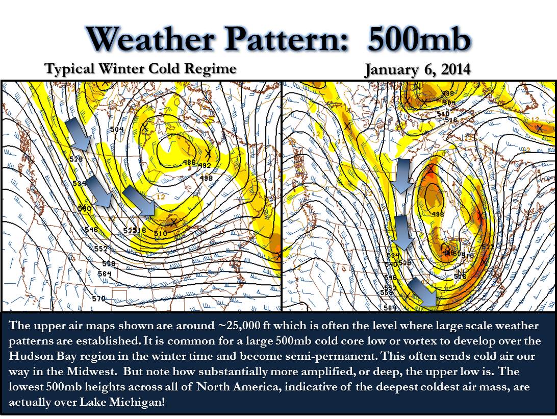
While this will be very cold, and about 15-20° below our average temperature for this time of year, it could be a lot worse. Two years ago today our 'polar vortex' pattern was much colder, and persistent. January 6th 2014 saw a high temperature of -7° and a low temperature of -18°. This was just a degree away from the coldest January 6th Rockford has seen. Overall temperatures the 5th-7th in January 2014 were about 30°-40° below average! There was even a time where Rockford saw 40 consectutive hours below zero. And the chills were even worse! On the morning of January 6th 2014, the lowest wind chill recorded was -46°!
This cold snap was brought on by a few different factors. One of those, is that the Midwest saw quite a few back to back cold fronts that continued to usher in colder and colder air. The fronts would continue to establish a very cold air mass in place for the area.
We also had a large snow pack in place across the Great Lakes and Midwest region, this reinforces the cold pattern. The final piece to the puzzle relates to the very popular weather term, the 'polar vortex'. Typically in winter, it's common for a low pressure system to set up shop in southern Canada that ushers in colder air. However in 2014 a piece of the polar vortex dislodged from where it typically sits and brings even colder air into the region. It's not uncommon for a piece of the polar vortex to make it's way close to the area. What was unusual was how long it stuck around, keeping temperatures far below average for a long time. The graphic below, courtesy of the National Weather Service, shows the difference between a normal cold snap, and one due to the polar vortex. You can see a big difference between the two, with the one on the right showing a very amplified pattern that taps into arctic air.
While it will be quite a bit colder next week, it doesn't look to last too long. Temperatures look to return to return to more seasonable temperatures later in the month.
Subscribe to:
Posts (Atom)