Friday, January 14, 2022

Friday's Snowfall Potential, Slick Spots Possible for the Evening Commute

Friday's Snow Chances:

For some, Thursday was a rather enjoyable day thanks to the mild temperatures and the sunshine that poked through during the afternoon. For others, mainly areas to the south and west of the Rockford, dense fog continued to be an issue. 

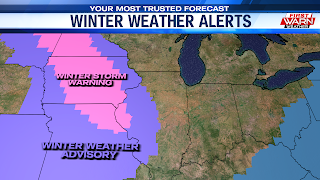
But now our attention turns to the winter storm system that’s likely going to impact the Midwestern regions of the U.S over the next 24 hours. While we currently don't have counties under a winter weather alert, the story changes the further west you travel. Northeastern and eastern Iowa has been placed under a Winter Weather Advisory, with areas stretching from northern North Dakota to northeast Missouri being placed under a Winter Storm Warning. 

Locally, Friday kicks off on a quiet but cloudy note, with snow chances slowly ramping up as the afternoon progresses. With northeast flow pulling in dry air from the Great Lakes, the snow will have some dry air to fight off at first. By the late afternoon hours, our atmosphere will become fully saturated, allowing this event to get underway. 

Guidance shows light snow showers becoming a little more widespread early tonight. Because of the westerly nature of the storm system's track, the heaviest and steadiest snow is expected to fall west of the Mississippi River. It does look like our snow chances will continue into midnight, with conditions quickly winding down early Saturday morning. If you plan on traveling this evening, allow for extra time as slick spots will be possible.

Snowfall Potential:

As far as accumulations are concerned, areas east of Freeport and Amboy will be on the shorter end of the spectrum, picking up as much as an inch of snowfall. While that doesn't sound like much, it will still be enough for a slick spots to form on the roadways this evening. Areas from Freeport to the Mississippi River look to end up with totals ranging from 1"-2", with highs accumulations for areas west of the river. The weather turns quiet and dry for Saturday, with clouds giving way to some afternoon sunshine. Look for highs in the mid 20s both days this weekend. Single digit temperatures are likely Saturday night.

Thursday, January 13, 2022

Dense fog for some Thursday evening


A DENSE FOG ADVISORY has been issued for Stephenson, Ogle, Lee, Carroll, Whiteside and now DeKalb counties until Midnight as dense fog has developed over the last several hours, dropping visibility in some locations to zero.

Added moisture from the recent snowmelt and warm temperatures allowed fog to develop late Wednesday night and Thursday morning.  While the fog mostly cleared across northern Illinois and southern Wisconsin by late morning and early afternoon, it moved back in across portions of north-central Illinois.


As the evening progresses fog may continue to develop throughout the region, with dense fog remaining a concern for some locations.  Temperatures are also another concern as the fog prone areas spent most of the afternoon in the low 30s.  As temperatures drop near/below freezing Thursday evening, freezing fog and icy spots are certainly possible due to the residual moisture from the recent melting snow.  Be careful if you're out traveling this evening.  It looks like fog will last through Friday morning with temperatures starting out in the mid/upper 20s.


A Cloudy & Mild Thursday Gives Way to Snow Chances Late-Friday

AM Fog, Cloudy Skies Linger:

Temperatures both yesterday and Wednesday were able to climb into the low 40s, making for quite a bit of snow melt across the area. The combination of the added low-level moisture and light surface winds overnight has led to the development of fog across the area this morning.

If you plan on heading out for the morning commute, it'll be wise to allow extra time to get to your destination. Much like Wednesday, cloudy skies are expected to dominate for most of the day. Simply due to the fact we’ll be starting off with temperatures in the middle and upper 20s, afternoon highs will likely top out in the mid 30s. A brief flurry or two, especially early on in the day, cannot be completely ruled out. However, Guidance does show a vast majority of our Thursday remaining dry.

Friday's Clipper System:

A more impactful and stronger storm system is scheduled to dive into the Midsection of the United States late-Friday into early Saturday. As of early this morning, the National Weather Service placed areas to our north and west under a winter storm watch and a winter storm warning.

Forecast models continue to keep the overall track of the surface low well to the west of the area, meaning the Stateline will be missing out on the greatest snowfall potential. Locally, our Friday kicks off on a cloudy and quiet note, with snow flurries and showers sliding in late in the afternoon into Friday evening. As far as accumulations are concerned, I still think it's a bit too early to be throwing out any numbers. 

But it does seem like our areas closer to the Mississippi River will have a somewhat better opportunity at seeing minor accumulations than those who live along or around I-39. A few snow showers may linger into the early Saturday, with cloud cover dominating our skies once again. 

On the backside of Friday's system, a round of colder air filters into the western Great Lakes, limiting our highs to the mid-20s. Once this clipper system dives into the deep south, it's set to undergo rapid straightening, becoming a powerful wind-machine and snow-maker for areas along the Appalachian mountains and the Mid-Atlantic. 

Wednesday, January 12, 2022

Patchy fog possible Wednesday night following recent warmth


Areas of fog may develop Wednesday evening following a recent warm up that brought high temperatures into the upper 30s and low 40s Tuesday and Wednesday.

Following a few light rain showers Wednesday afternoon, skies were quick to clear across the area.  With a partly cloudy sky expected overnight, the light winds and added moisture from the recent snow melt will be a perfect setup for at least patchy fog to develop; some of which may become locally dense.


The fog will last through Thursday morning before northwest winds pick up slightly mid to late morning.  Another quick moving low, currently crossing the Northern Plains, will pass mostly through Iowa and southern Illinois during the day.  A weak low pressure system at the surface develops in response and could bring a few flurries/light snow showers and/or sprinkles throughout the morning.  Skies will remain mostly cloudy with highs in the mid 30s for the afternoon. 


Warmer-Than-Average Trend Set to Continue Ahead of Late-Week Snow Chances

January Swings:

After kicking off the work week with another round of disrespectfully cold Arctic air, southwesterly to southerly winds brought an opportunity for the region to thaw out on Tuesday. Officially, Rockford came in with a high of 40° yesterday, making for the warmest day of 2022 thus far. Despite the fact that Wednesday features a considerably cloudy sky, this warmer than average trend is still expected to stick around.

Light Mix Possible:

Southwesterly winds overnight resulted in a slower cool-down process, allowing most of our spots to land in the upper 20s and low 30s. A significant difference compared to the single-digit lows that were being felt Tuesday morning. 

A weak system sliding into the western Great Lakes will bring a chance for a very scattered light mix of flurries and ran into the mid-day hours. Otherwise, a lingering southwest breeze will allow temperatures to once again top out in the mid to upper 30s. Guidance does show enough moisture moving in late in the day for the potential for fog to develop. Along with the fog potential, we do keep a mostly cloudy sky into tonight, with flurry chances returning by Thursday morning.

Late-Week Snow Chances:

A fast-moving disturbance is likely to spread light snow in our direction just in time for when you head out for the morning commute. Despite the recent warmth, road temperatures may still be cold enough for slick spots to occur. If traveling, be sure to use extra caution. Conditions then quiet down for Thursday afternoon, with highs topping out near the freezing mark (32°). 

Friday features a stronger storm system that brings a better opportunity for portions of Midwest a shot at seeing accumulating snowfall. For northern Illinois and southern Wisconsin, snow chances do remain possible, especially Friday night into the early stages of Saturday. 

The one principle or component of the forecast that is limiting us from being in the greatest snowfall potential is the storm system's track. Guidance the past few morning's have come in with a rather westward shift in the overall track, allowing portions of the Dakotas, Minnesota, Iowa, and Missouri to be the areas with the greatest snowfall potential. Still, there is time for the forecast to change so stay up-to-date with the forecast over the next 24 to 48 hours. As the surface low dips to our west/southwest, colder air slides in for the weekend, dropping high temperatures into the low to mid 20s.

Tuesday, January 11, 2022

Bitterly Cold Tuesday Morning, Slowly Warming Back Up

Coldest Period:

Historically, January 11th marks the beginning of the coldest period of the calendar year for the Rockford area. Up until the 28th, average highs hover around 29-degrees, with our average lows sitting near 14-degrees. 

While we do start off the coldest period of the year with an arctic air-mass, a warm and organized southwest breeze will help temperatures climb closer to average by this afternoon. 

Slowly Warning Up:

Our Tuesday does begin with the leftovers of this most recent Arctic cold snap. Fortunately, once the sun rises, winds out of the south-southwest will help pull us out of the teens and into the upper 20s by the late-afternoon hours. 

Wind gusts could approach 30 mph, especially between noon and 5PM. Clouds are expected to gather up late Tuesday night into early Wednesday morning as our next disturbance slides in. There will be enough moisture in the low-levels for a few flurries to occur before sunrise.

Midweek Outlook:

Guidance does show cloud cover sticking around for a majority of our Wednesday, with highs climbing back into the low to mid 30s. The disturbance that I mentioned earlier is expected to track to our north late in the day, bringing a cold front through Wednesday evening. 

It doesn't look like we'll be dealing with a disrespectfully cold air-mass like we have the past couple of cold frontal passages. Temperatures only look to drop by a couple of degrees by Thursday afternoon, with highs in the low 30s. A few flurries will be possible during the early stages of the day, with cloudy skies lasting into the afternoon.

Monday, January 10, 2022

Winds increase Tuesday bringing temperatures out of the teens


Monday's high temperature of 14 degrees was the fourth time this month the temperature in Rockford has officially had a high temperature in the teens.  For the first week and a half of the month, the average monthly temperature is nearly seven and a half degrees below average.  Average highs this time of year should be in the upper 20s.

Monday night will be another cold night as the low drops through the single digits, down below zero for the start of Tuesday.  The forecast low is -5 degrees, but the wind chill could make it feel more like -10 to -15 degrees Tuesday morning.


Northwest winds are set to continue through Monday evening but will shift around to the southwest Tuesday morning, gusting to around 30 mph throughout Tuesday afternoon.  The southwest wind will bring temperatures into the mid and upper 20s by late afternoon, increasing into the low 30s by Tuesday night.  Wind chills, however, throughout the day will feel more like the teens and low 20s.

West winds on Wednesday will prevent temperatures


from falling behind another cold front, with highs holding in the low to mid 30s.  The cold front could bring with it a few flurries or even a couple sprinkles late Wednesday into Thursday.