
For some, Thursday was a rather enjoyable day thanks to the mild temperatures and the sunshine that poked through during the afternoon. For others, mainly areas to the south and west of the Rockford, dense fog continued to be an issue.
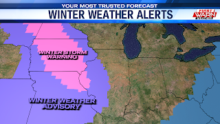
But now our attention turns to the winter storm system that’s likely going to impact the Midwestern regions of the U.S over the next 24 hours. While we currently don't have counties under a winter weather alert, the story changes the further west you travel. Northeastern and eastern Iowa has been placed under a Winter Weather Advisory, with areas stretching from northern North Dakota to northeast Missouri being placed under a Winter Storm Warning.

Guidance shows light snow showers becoming a little more widespread early tonight. Because of the westerly nature of the storm system's track, the heaviest and steadiest snow is expected to fall west of the Mississippi River. It does look like our snow chances will continue into midnight, with conditions quickly winding down early Saturday morning. If you plan on traveling this evening, allow for extra time as slick spots will be possible.

As far as accumulations are concerned, areas east of Freeport and Amboy will be on the shorter end of the spectrum, picking up as much as an inch of snowfall. While that doesn't sound like much, it will still be enough for a slick spots to form on the roadways this evening. Areas from Freeport to the Mississippi River look to end up with totals ranging from 1"-2", with highs accumulations for areas west of the river. The weather turns quiet and dry for Saturday, with clouds giving way to some afternoon sunshine. Look for highs in the mid 20s both days this weekend. Single digit temperatures are likely Saturday night.
No comments:
Post a Comment