Thursday, July 7, 2022

Few PM Showers, Better Odds Arrive After Sunset

Very Wet Start to July:

Wednesday's dry afternoon was just what the doctor ordered after we kicked off the week with multiple rounds of thunderstorms. 

All in all, the 3-day total at the Rockford International Airport came to 2.39", which is now tied for the 8th wettest start to July on record. While dry conditions greet us out the door this morning, the potential for showers increases into by sunset. 

Few Afternoon Showers:

Thursday starts off on a dry note, with cloud cover increasing towards mid-day. Any showers we see during the later half of the day will be widely-scattered and light in nature. More widespread showers become likely after sunset, and then taking us through most of Thursday night. 

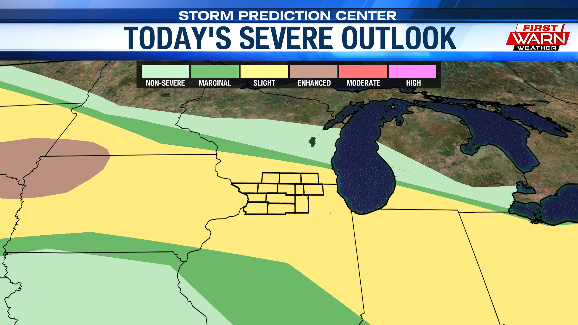
Just to be safe, have the umbrella on hand today. Similar to yesterday, the thunderstorm and severe potential is very low. However, an isolated non-severe thunderstorm or two cannot be ruled out. With us being on the northern side of a frontal boundary, northeast flow will once again limit our high temperatures to the lower 80s. Showers should wrap up quickly Friday morning, allowing conditions to dry out for the afternoon.

More Comfortable:

Following Friday morning's cold front, the weather dries out and becomes less humid as we enter the weekend portion of the week. 

An area of high pressure will be quick to take over the areas surrounding the Great Lakes. Plenty of sun can be expected Saturday, with a few more clouds floating across the sky on Sunday. Towards the end of the weekend, winds will make a big turn to the south, allowing temperatures to slowly climb into the beginning of next week. Highs peak in the upper 80s Monday ahead of another cold front that will bring highs back in the lower 80s for Tuesday.

Wednesday, July 6, 2022

Brief Break from the Rain Today, Showers Likely Thursday

Much-Needed Rainfall:

Mother nature has been busy throwing multiple soaking rain opportunities at the Stateline the past couple of days. What's completely mind blowing is that the total rainfall for the past two days equates to more rainfall than the entire month of June. 

Rainfall in which we DESPERATELY needed! Looking ahead, we're not out of the woods just yet as we have a few more rain chances before our weather pattern simmers down by week's end. 

Unsettled Pattern Continues:

A few showers, isolated thunderstorms may linger into the early morning hours. However, much of our Wednesday remains fairly dry, with highs only climbing into the lower 80s.

Despite the fact that our high temperatures are trending cooler, humidity levels remain high this afternoon. The umbrella will more than likely be needed Thursday as rain chances go up thanks to an area of low-pressure slides to our south.

Relief Moves In:

Another cold front is expected to slide through the region late Thursday night into Friday. This, along with an area of high pressure locked over the Great Lakes, will allow relief to settle in. 

Highs into the weekend remain in the lower 80s, with lows cooling to as low as the upper 50s Saturday night. So, if you are not a huge fan of the humidity as of late, less humid times are on the way. Friday, Saturday, and most of Sunday feature a good amount of sun, with the next rain chance arriving Sunday night.

Tuesday, July 5, 2022

Tuesday evening severe weather update

 UPDATE: The SEVERE THUNDERSTORM WARNING for Jo Daviess and western Stephenson counties has been canceled.

A SEVERE THUNDERSTORM WARNING remains in effect for Jo Daviess and western Stephenson counties until 9:45pm. Storm located near Elizabeth, just west of Stockton, are moving to the southeast at 25 mph and capable of producing wind gusts to 60 mph. The SEVERE THUNDERSTORM WATCH remains in effect for northern Illinois and southern Wisconsin until Midnight. Thunderstorms moving across northern Illinois and southern Wisconsin are currently not severe, but are producing torrential downpours. Under these heavy downpours rainfall rates of an inch or two per hour can be expected, producing localized flooding.

FLASH FLOOD WARNINGS remain in effect for parts of Green and Rock counties in southern Wisconsin as anywhere from 2.5-3.5 inches of rain has fallen. An additional 1.5-3.0 inches are possible in the those areas. These heavy showers are also forming in an area that received heavy rainfall Monday night. A FLASH FLOOD WARNING was also issued for northern Jo Daviess and Stephenson counties until 3am as rainfall totals so far range from 0.5 inches to 1.5 inches. An additional 1-3 inches of rain are possible through the evening.

A strong storm complex continues to move towards eastern Iowa producing numerous severe thunderstorm warnings, especially along its northern half. Reports of wind damage continue to come in across parts of Iowa Tuesday evening. This storm is currently moving to the east/southeast and is expected to move towards NW Illinois within the next hour, moving towards Rockford around Midnight. The intensity of the storm may be muted some given the current storm activity over southern Wisconsin and northern Illinois, however, areas that have not had any storm activity this afternoon and evening may have a slightly higher risk for a damaging wind threat through the early overnight.

All of northern Illinois and southern Wisconsin remain under a slight risk for severe storms, but parts of Jo Daviess, Carroll, Whiteside and Lee counties have been upgraded to an enhanced risk with damaging winds being the primary concerns. Further north, significant flooding may become more of a concern across parts of Wisconsin and northwest Illinois. The timing of this storm complex appears to be from roughly 10:30pm to 11:30pm west of Rockford, and around Midnight to 1am for Rockford. 

Heat Advisory Issued, Another Chance for T-Storms Arrives Late

Hot, Oppressive Tuesday:

Mother nature brought her own fireworks for the 4th of July as multiple rounds of thunderstorms tracked through the Stateline. 

All of which brought an elongated threat for severe weather and the potential for flash flooding. Now, with us still under this "ring of fire" weather pattern, the threat for severe weather returns later today. However, it'll be today's excessive heat and humidity that becomes the bigger headline.

A HEAT ADVISORY will be in effect for the entire region from mid-day till 8PM. 

During this time, highs temperatures will be peaking in the low to mid 90s. That, along with dew point temperatures in the low to mid 70s will allow heat indices to either touch or eclipse the triple-digit mark. 

If you can, limit time outdoors today. If that option is off the table, please be sure to have plenty of water on hand and take frequent breaks in the shade. Today's heat and humidity will be one of the big reasons why a few storms will be possible later in the day. And yes, severe weather is also on the table.

Late-Day Threat:

Similar to Independence Day, the entire Stateline has been placed under a Slight Risk (level 2 of 5) for severe weather. This is for the round of thunderstorms that look to form along a westward-moving lake breeze boundary late Tuesday. 

For any storm that showcases severe characteristics, damaging winds and hail will be the biggest concerns.


And of course, with the vast amount of moisture in our atmosphere, heavy rainfall and flash flooding will also be a big concern. Guidance continues to keep a chance for scattered showers and thunderstorms overnight, with a frontal boundary sinking to our south by early Wednesday morning. The northeast flow behind the front will help cool our high temperatures back down into the 80s for the remainder of the work week.

Monday, July 4, 2022

Daily T-Storm Chances, Heat Advisory Issued for Tuesday

Stuck in the "Ring of Fire":

You couldn't ask for better weather for the start of the Independence Day weekend. Both Saturday and Sunday featured sunshine from start to finish, with highs landing in the upper 80s. 

However, as we were hinting at late last week, the best rain and thunderstorm potential was unfortunately slated for Independence Day itself and the days that follow. 

This is because we are entering a more active weather pattern that we typically see during the summer month, a pattern we call the "ring of fire". Long story short, a ridge of high pressure sets up over the southern and central plains, placing the jet closer to the U.S/Canadian border. 

The northward adjustment of the jet places the Stateline in the perfect position to receive any cluster of storms that develop at the top of the ridge. In this week's case, this will bring us daily rain opportunities. The tricky part about a forecast like this is the timing as it all depends on what happens earlier in the day, or even what happens in the days prior.

Mother Nature's Fireworks:

The 4th actually starts off on a quiet note, with some sunshine possible early on. By mid to late morning, clouds are expected to increase, with the first round of showers and thunderstorms quick to follow. Guidance places the first round of showers and storms into our region around midday, with storms likely to continue in a scattered fashion, through mid to late afternoon. 

While it looks like the initial round doesn't pose much of a severe threat, that can't be said for the second round. Earlier this morning, the Storm Prediction Center placed the entire region under a Slight Risk (level 1 of 5) for severe weather. Now, the timing of the first round is KEY. 

If the thunderstorms slide in earlier, the 2nd round will track in around the time firework shows are to commence. However, if this afternoon's chances are slow to move out, this would likely delay the development of the 2nd round by an hour or two. As mentioned, this round does carry with it a higher chance for strong to severe storms, with gusty winds and heavy rainfall being the biggest concerns. If you have any plans this evening, stay up-to-date with the forecast and keep an eye on that radar! Once this cluster is to our east, conditions simmer down into Tuesday.

Daily T-Storm Chances:  

But just as quick as we are to quiet down, another chance for thunderstorms arrives late-Tuesday. For that, the Storm Prediction Center has placed the region under a Slight Risk (level 2 of 5) for severe weather. Similar to today's threat, damaging straight-line winds, heavy rainfall, and a tornado or two will be the biggest concerns. 

Heat Advisory Issued:

Along with the severe potential does come dangerous heat as a southwesterly wind will place Tuesday's highs in the low to mid 90s. With dew points in the upper 60s and low 70s, allowing the afternoon hours to feel quite oppressive. 

As of this morning, the National Weather Service has placed our western areas, Jo-Daviess, Stephenson, Carroll, and Whiteside Counties, under a HEAT ADVISORY. This will be in effect from 12PM to 8PM Tuesday as heat indices will more than likely exceed the triple-digit mark. If you can, avoid being outdoors for a prolonged period of time. If you can't drink plenty of water and take frequent breaks in the shade. Temperatures cool back down to the 80s, with another chance for thunderstorms arriving Wednesday and Thursday.

Sunday, July 3, 2022

Quiet Sunday night; Storms possible for the 4th


The weekend was hot, but not overly humid as temperatures warmed into the mid and upper 80s both days. Following a cold front Friday afternoon there was a nice drop in the dew point temperature, with numbers falling through the 50s. This helped keep the humidity at bay through the weekend. For anyone who may be enjoying any Fourth of July festivities Sunday evening, the weather looks perfect. It'll be a warm evening with a breeze from the south. Temperatures will remain in the 80s through sundown, slowly falling back once the sun sets. Skies remain clear making for perfect viewing of any fireworks displays that may be taking place.


All eyes, however, will be paying close attention to the forecast for the actual holiday - Monday - as showers and thunderstorms are likely to impact parts of the region not only during the afternoon, but possibly at night. As we enter into the first full week of July, we are also entering into a very typical summer-like pattern, known as the 'ring of fire' pattern. Under this pattern, thunderstorms and storm clusters form on the outer edge of a strong, and usually rain free, heat dome. These storms follow the winds within the jet stream, feeding off of the heat and instability. It's an often difficult type of pattern to forecast for as the exact path and timing of those storms depends on quite a few factors; a couple of those being any overnight or early morning storm activity, storm activity upstream and impacts that may have on further development downstream. For Monday, it does look like we have an opportunity for a couple storm systems to move through the region; the first during the afternoon and the second later in the evening/night.


Skies should begin relatively quiet Monday morning ahead of increasing cloud cover from the west. Temperatures will fall into the mid 60s during the early morning, rising into the mid 80s by the afternoon. An upper level disturbance currently over the Rockies is forecast to move through the Plains and right across northern Illinois and southern Wisconsin either late morning or early afternoon. It looks like our window for this first wave is roughly Noon to 5-7pm. There will likely be a dry period following the first round of rain during the evening, perhaps a couple hour window, before the second round moves through.


That second round of thunderstorms is expected to develop to our north/northwest sometime during the evening, shifting to the southeast towards southern Wisconsin and northern Illinois. These thunderstorms will be developing on the nose of an increasing low level jet (strong winds in the lowest levels of the atmosphere), as well as with increasing moisture and instability. The big question mark at this point is when do the storms develop and what is the exact track. As it stands Sunday evening, the storms could move right over southern Wisconsin and northern/northeast Illinois as early as 9pm/10pm, or hold off until after 11pm. It's also possible that the storms form more to the northeast, passing through southeast Wisconsin and northeast Illinois, bypassing most of the area. Again, this second round depends on what happens earlier in the day. Wherever these storms develop, there is a risk for a few strong/severe storms late Monday evening. Strong winds and heavy rainfall would be the biggest concerns.

If you are planning on heading out for any of the fireworks displays, please make sure you keep a watchful eye on the forecast for the evening. We'll continue to provide updates on our storm chances throughout the day.  

Friday, July 1, 2022

Early Morning Storms, Isolated Chances Over 4th of July Weekend

Drought Worsens:

Rain opportunities during the 2nd half of June were few and far between, resulting in the expansion of our regional drought. Thursday's edition of the drought monitor indicates that much of the region is now experiencing abnormally dry conditions. While our rain chances remain isolated over the 4th of July weekend, better opportunities may present themselves early next week.

Early Morning Storms:

Our first shot at some rain comes in the form of a weak cold front early Friday. Models this morning kept chances into the late-morning hours, with skies slowly clearing during the afternoon. 

If you plan to step out the door early, it wouldn't hurt to have your umbrella with you. There may be a chance for a lingering shower or two at the start of City Market. However, much of the event will be dry. Once the front is through, winds will turn to the northwest, resulting in a somewhat cooler afternoon with highs in the lower 80s. Skies remain mostly clear overnight, with lows falling into the lower 60s by sunrise Saturday. 

4th of July Weekend:

Saturday and Sunday feature dry conditions for the most part. However, energy moving in aloft may result in more cloud cover and a small shower chance Saturday afternoon. High temperatures will range from the mid to upper 80s, landing a few degrees above early-July standards. As we've been hinting at the past few days, Independence Day does also feature a chance for rain, especially during the evening and overnight hours. 


While it's too early to cancel any plans for the day, you'll definitely want to pay close attention to the forecast for the 4th of July. Forecast models then showed a few more systems sliding down a upper-level ridge over the central plains, allowing rain chances to carry on into the middle of next week. However, the confidence level on these rain chances is still low considering we are several days out. Something we'll have to keep an eye on!