Sunny and 75... Yes, that is the title of a very popular Kenny Chesney song. But that phrase also describes the beautiful weather the Stateline endured on the first FULL day of spring.
While yesterday's high lands well above the average high of 49°, it still wasn't record warmth as the peak of the March 2012 heat wave occurred on the 21st (84°). But being only 9-degrees away from tying the record high should give you a pretty good indication on how warm it was yesterday. Unfortunately, our weather pattern takes a big turn as we look to trade in yesterday's sunshine and warmth for long-lasting rain chances.
Rain Chances Return:A storm system sliding into the Midwestern section of the U.S has allowed moisture to increase locally. This has result in cloudy skies and the chance for light rain showers as you prepare for your day.
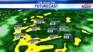
The rain will be steady through the morning hours before becoming more scattered during the afternoon. Before heading out, make sure to have an umbrella with you. Winds will primarily be out of the southeast, gusting to 30 mph at times. This will result in MUCH cooler day overall with temperatures rising into the low to mid 50s. As this area of low pressure moves closer to the Stateline, rain will pick up in intensity Tuesday evening and Tuesday night.
Guidance does show the possibility for a few rumbles of thunder. With that being said, severe weather is likely out of the question. Scattered showers and drizzle will continue into the middle of the work week as the center of our rain-maker moves across northern Illinois.Highs on Wednesday will once again warm into the low 50s before cooler air wraps in Wednesday night into Thursday. Rain chances with this low pressure system will more than likely come to an end Thursday. However, thanks to the cooler air that filters in, a few snowflakes may mix in. Highs fall into the low 40s Thursday afternoon before climbing back near 50 Friday. Rainfall-wise, models have been consistent dumping a half inch to an inch across the area.


No comments:
Post a Comment