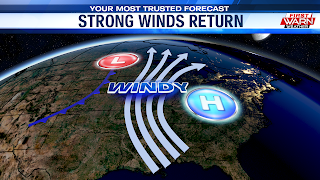
A rather similar set up to the one we had on Tuesday aims to bring strong winds back to the Stateline as we jump into the weekend. The only difference will be the direction in which our winds will be blowing out of, at least to start.
With anticyclonic flow (high pressure) sitting over the Tennessee Valley and a cold front draped to our west, winds throughout the day will be blowing out of the south and southwest. Wind gusts will range from 35-40 mph, which should be enough to bring our temperatures up to the 50° mark. And that's even with much of the day being spent under a mostly cloudy sky. Like Tuesday's cold front, there will be the small chance for a few stray showers before it's passage, likely this evening into early tonight.
Wind Advisory:
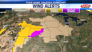
The strongest winds will be felt as the cold front itself is passing through the region overnight. For that, the National Weather Service in Quad Cities has placed Jo-Daviess, Stephenson, Carroll, and Whiteside Counties under a WIND ADVISORY from 6PM this evening to 3AM Saturday morning.
Winds during this time will be capable of gusting up to 50 mph. Once the front is through, winds will immediately shift to the northwest, allowing our next cold snap to settle in. Temperatures are expected to rapidly fall into the low 20s, with possibly a spot or two landing in the upper teens. With the quick drop in temperatures in mind, any moisture that is left behind by this evening shower chances will freeze up quick. So please keep an eye out for any slick spots whether it be in the parking lot, sidewalks, or while driving.
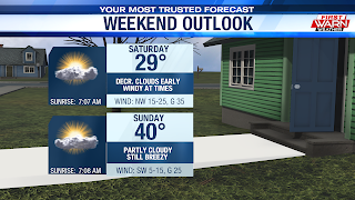
Weekend Outlook:Saturday is to be a repeat of Tuesday, minus the thick cloud cover. With a rather bitterly cold north to northwesterly wind in place, high temperatures will be severely restricted to the upper 20s. Even further down the thermometer will be our wind chill values as they look to register in the teens for a majority of the day.
All in all, a good day to nothing but relax indoors. But if you have to be out and about at any point Saturday, plan on bundling up in layers! Improvements filter in Sunday as our next area of high pressure slides to the east of the region. This will allow southwest winds to quickly return, bringing our high temperatures back near seasonable-levels. 40s continue into early next week ahead of another cold front that will cool us down a little into the middle of next week!


No comments:
Post a Comment