Tuesday, June 30, 2015

Look to the west, you may be able to catch a spectacular sight

Here are a few of the photos we've received so far this evening:
Barb Roberts
Stillman Valley


Jeff
Machesney Park
Pat Hochstein
Franklin Grove
Larissa Miller

Pam Munger


According to Sky and Telescope, many across the United States will get a spectacular view tonight of the planets Venus and Jupiter.  Have you noticed in the night sky how both the planets have been close to each other?  According to the online article, at the beginning of the month, the two planets were 20 degrees apart in the evening sky.  Over the past several weeks, Jupiter and the stars behind it have been gradually slipping lower in the evening twilight.  But Venus has remained high up.  Because of this, the planets will come within a third of a degree of each other, making it appear as one bright, double star in the evening sky.

The best viewing will be to the west about an hour after sunset, so around 9:30'ish.  Unfortunately for us, the cloud cover might be just a little too thick to get a good viewing.  But, it's worth a try.  Some have even called it the 'Star of Bethlehem'.  If you are able to see this awesome view, be sure to send in your photos: weather@wtvo.com

Canadian Forest Fires Impact US Sky Cover

It was a very pleasant day in Rockford and along the Stateline, but you may have noticed a bit of a milky/hazy look to our clouds. That's because smoke from wild fires in Alberta, Canada has drifted into much of the central United States. The jet stream pattern was positioned in a way so as to take that smoke over much of northern Illinois and southern Wisconsin. Visible satellite pictures gave us a very clear picture of this trend today and will keep us under mostly cloudy skies for tomorrow!

Record Breaking June

With the rain the past couple of days the State of Illinois broke it's previous record for the wettest June on record, breaking the old record from 1902. With the rain totals  now in from yesterday's storms; its not only the wettest June but it is also the second wettest month the State has seen - since records started in 1895. The statewide average precipitation is now up to 9.37 inches!


The old June record was 8.27 inches set back in 1902. With 9.37 inches we are now beating this by 1.10 inches, and currently 5.17 inches above the June average of 4.20 inches. The only wetter month for the state was September of 1926 where Illinois received 9.62 inches


With more storms and rain expected across the state we will see this total jump, and will have June monthly totals tomorrow.

Last Day of June Gets an Extra Second!

Today will be one second longer than any other day. This day we add one leap second at 6:59pm central time or 23:59:59 UTC time. This is done to keep atomic and astronomical clocks synced together. They begin to differ because the rotation of the Earth isn't always constant, it is actually slowing down, but does so unpredictably. This makes it very hard to set clocks accurately. The first time we saw leap seconds added was back in 1972, and at the time they had to add 10 seconds  because the two different clocks were so far apart. While many people won't notice the change, there could be some issues with computers that haven't been programmed to this extra second. The last time we added a leap seconds - in 2012 - there were some computer sites that crashed because they weren't adapted for the change. For more information on the leap second  you can click here. I hope you enjoy your extra second!

Monday, June 29, 2015

Updated Monday evening weather


There's been no shortage of significant weather this past week, and tonight was no exception.  What started as building thunderstorms this afternoon and evening, turned into a tornado warning for Lee County.  Now, tonight's atmospheric set up was nothing like that of last Monday when a supercell thunderstorm produced an EF2 tornado in Woodhaven Lakes.  The atmospheric set up tonight was more conducive for brief tornadoes and weak funnel clouds, but dangerous nonetheless. 

A shift in the jet stream pattern over this past weekend allowed for an extensive ridge to build across the Northwest, causing record breaking heat in the Northwest, and a cooler weather pattern across the Midwest.  But, what that cooler pattern has allowed for are many upper level lows to spin down from the northwest.  While the atmosphere isn't necessarily primed for active and severe thunderstorms, each low that comes down from the northwest causes just enough spin in the atmosphere for thunderstorms to develop causing rotation. 

While the severe threat remains low, there are thunderstorms moving through Southwest Wisconsin and Northeast Iowa.  Should these hold together, they will make it into Northern Illinois between 9pm and 10pm.

Wettest June on Record - Breaking 113 Year-Old Record

It's officially the wettest June on record for the state of Illinois; according to the State Climatologist office for Illinois. Illinois has now passed the old record of 8.12" set back in 1902.  Now surpassing the 113 year-old record, the rainfall total currently sits at 8.91". With almost 2 days left in the month, and more showers and storms in the forecast, we will see this number continue to rise.


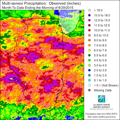
For the city of Rockford, we are officially right where we should be in  terms on rain. The official number is observed at the Rockford airport. We are sitting right at 4.39" which is spot on for the month. However, locally we have received much higher amounts, and you can see with this rainfall map of the state.

The areas in green are 5-8 inches of rain. The blue to purple shading is 8 to 11 inches! You can see that most of northern Illinois is in the 5-11 inch category, while southern Wisconsin has seen about 1-5 inches. We don't see much of a break from the rain anytime soon - the Climate Prediction Center has us highlighted again for above normal precipitation through July.


Friday, June 26, 2015

In Total 10 Tornadoes Touched Down in Northern Illinois on Monday

On Monday June 22nd in total 10 tornadoes touched down through northern Illinois, with four of those being in the Stateline region.
Here are a few facts from the severe weather event.
A total of ten tornadoes occurred in Northern Illinois. Nine of those occurred from one long lived rotating storm which is known as a cyclic supercell storm. It tracked across Whitside and Lee counties, as well as LaSalle, Grundy, Will, and Kannakee counties.
The heaviest damage was in Coal City and Braidwood which was hit by an EF-3 tornado with maximum winds at 160mph.  The second was the Woodhaven Campgroung in Sublette (Lee County) caused by a high end EF-2 tornado with maximum winds at 130mph.
There were 12 people injured but not fatalities.


One tornado occurred in Whiteside county, one that started in Whiteside and tracked into Lee, and then two more in Lee county. Here's a break down of each tornado from the National Weather Service.


TORNADO #1: STERLING AND ROCK FALLS TORNADO...*

RATING:                 EF-1
ESTIMATED PEAK WIND:    100 MPH
PATH LENGTH /STATUTE/:  2.2 MILES
PATH WIDTH /MAXIMUM/:   75 YARDS
FATALITIES:             0
INJURIES:               0

START DATE:             JUN 22 2015
START TIME:             714 PM CDT
START LOCATION:         1 MILE NORTHEAST OF ROCK FALLS IL
START LAT/LON:          41.7909 / -89.6707

END DATE:               JUNE 22 2015
END TIME:               718 PM CDT
END LOCATION:           2.5 MILES SOUTHEAST OF ROCK FALLS IL
END LAT/LON:            41.7686 / -89.6402

SURVEY SUMMARY: MAINLY DAMAGE TO TREES AND POWERLINES. 


.TORNADO #2: WHITESIDE COUNTY TO LEE COUNTY TORNADO...

RATING:                 EF-1
PEAK WIND:              105 MPH
PATH LENGTH:            2.6 MILES
PATH WIDTH MAXIMUM:     50 YARDS
FATALITIES:             0
INJURIES:               0

START DATE:             JUN 22 2015
START TIME:             716 PM CDT
START LOCATION:         3.5 MILES SOUTHEAST OF ROCK FALLS IL
START LAT/LON:          41.7360 / -89.6509

END DATE:               JUN 22 2015
END TIME:               720 PM CDT
END LOCATION:           3.5 MILES WEST OF HARMON IL
END LAT/LON:            41.7099 / -89.6174

SURVEY SUMMARY: MAINLY DAMAGE TO TREES AND POWERLINES. DAMAGE TO
SIDING ON HOUSE.


 TORNADO #3: HARMON AREA TORNADO

RATING:                 EF-1
PEAK WIND:              105 MPH
PATH LENGTH:            7.5 MILES
PATH WIDTH MAXIMUM:     50 YARDS
FATALITIES:             0
INJURIES:               0

START DATE:             JUN 22 2015
START TIME:             728 PM CDT
START LOCATION:         2.5 MILES NORTHWEST OF HARMON IL
START LAT/LON:          41.7436 / -89.5917

END DATE:               JUN 22 2015
END TIME:               740 PM CDT
END LOCATION:           5.1 MILES EAST SOUTHEAST OF HARMON IL
END LAT/LON:            41.6971 / -89.4615

SURVEY SUMMARY: NARROW PATH OF MAINLY TREE DAMAGE. REAR FLANK
DOWNDRAFT DAMAGE WAS NOTED SOUTH OF THE PATH INCLUDING DAMAGE
A ROOF BLOWN OFF A BUILDING IN HARMON. 
STORM SPOTTERS ASSISTED WITH THE IDENTIFYING OF THE TORNADO. .


TORNADO #4: WOODHAVEN LAKES/SUBLETTE TORNADO 


RATING:                 EF-2
PEAK WIND:              130 MPH
PATH LENGTH:            7.8 MILES
PATH WIDTH MAXIMUM:     ONE HALF MILE
FATALITIES:             0
INJURIES:               7

START DATE:             JUN 22 2015
START TIME:             753 PM CDT
START LOCATION:         4.0 MILES SOUTH OF AMBOY IL
START LAT/LON:          41.6565 / -89.3213

END DATE:               JUN 22 2015
END TIME:               811 PM CDT
END LOCATION:           3.4 MILES SOUTHEAST OF SUBLETTE IL
END LAT/LON:            41.6044 / -89.1874

SURVEY SUMMARY: SIGNIFICANT TREES SNAPPED AND UPROOTED IN
WOODHAVEN LAKES CAMPING RESORT AREA. SEVERAL OF THESE FELL
ON RECREATIONAL VEHICLES.

NOTES: THIS WAS THE STRONGEST TORNADO DAMAGE RATING WITHIN LEE
COUNTY ITSELF SINCE AN F2 TORNADO ON JULY 8 1993. THE THREE
TORNADOES IN LEE COUNTY WAS THE MOST IN ONE CALENDAR DAY IN THE
TORNADO PERIOD OF RECORD /SINCE 1950/.  
 
 
 For the full report from the National Weather Service click here.

Tuesday, June 23, 2015

Updated Severe Weather Report Mon. June 22nd


TORNADO REPORT UPDATE: The National Weather Service in Chicago has upgraded the Coal City tornado to an EF-3 with max wind speeds at 160mph. At its widest point, the tornado was 3/4 mile wide traveling nearly 16.5miles.

The NWS has also confirmed that an EF-1 tornado occurred near Harmom, Illinois in Lee County.


They also have confirmed that the Woodhaven lakes and Sublette tornado as a high EF-2 with wind speeds up to 130 miles per hour and a half a mile wide path.


 So far there have been four total confirmed tornadoes for Northern Illinois on Monday. We'll keep you updated as the NWS assessment teams report in!

Possible Tornado Tracks from Monday afternoon


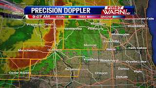
It was a long day for many across the Stateline yesterday after we saw multiple rounds of severe weather. The area was primed for severe weather with a very warm and humid air mass in place as well as a strong low pressure system moving just north of the area, and a strong jet headed into the region. In the morning a mesoscale convective system tracked across northern portions of the area with help from an approaching warm front. There were multiple severe thunderstorm warnings across the area with this storm. The biggest threats for this system were torrential rain and possible flooding, as well as hail and very strong damaging winds. While the storm was still in Iowa, wind speeds were clocked at 93.9mph! It weakened a bit but we still saw 70mph wind gusts across the area. This led to quite a few reports of damage across northern Illinois and southern Wisconsin.


The low pressure system tracked just north of the area with a trailing cold front. This front along with some help from outflow boundaries helped with storm development later in the day. A tornado watch was issued just before 4:00pm for southern portions of the Stateline area. This is where we saw multiple tornado warnings for a cyclic supercell that tracked through Whiteside and Lee counties in the early evening. The confirmed tornado was in Sublette which is in fair south eastern Lee county and then tracked to the south east. The National Weather Service from multiple agencies will be out this afternoon and evening taking damage surveys on the ground as well as in the air to confirm how many tornadoes hit the area. However here is a look as some of the rotation paths that were indicated on radar. You can see five highlighted areas that the National Weather Service will be looking at today. If you have storm pictures, of the damage, the storm itself, or even interesting clouds you can send them to weather@wtvo.com or tweet them to us. We also have the First Warn Weather App that lets you send them in! Damage pictures are a great tool for the NWS to help determine what type of damage occured.

Monday Rain Totals

Along with the severe weather threat yesterday of tornadoes and damaging straight line winds, the Stateline area also received torrential rain fall within the storms. Here's a look at some of the local rainfall amounts from the NWS.


STERLING 4NE (LEE)...........................2.60
PAW PAW (LEE)................................2.58
DIXON (LEE)..................................2.28
AMBOY (LEE)..................................2.19
MENDOTA (LA SALLE)...........................2.16
DIXON 3NNW (LEE).............................2.05
SUBLETTE (LEE)...............................1.93
ASHTON (LEE).................................0.73
BYRON 3N (OGLE)..............................0.57
ROCHELLE (OGLE)..............................0.53
STEWARD (LEE)................................0.46
BEECHER 3SSE (WILL)..........................0.39
ROCHELLE (OGLE)..............................0.38
BELVIDERE (BOONE)............................0.36
ELK GROVE VILLAGE 1ESE (COOK)................0.35
DE KALB 2NNE (DE KALB).......................0.35
ROCKFORD (WINNEBAGO).........................0.34
MALTA (DE KALB)..............................0.29
DE KALB (DE KALB)............................0.27 ELK 
WOODSTOCK 5NW (MCHENRY)......................0.25
GENOA (DE KALB)..............................0.23 
WOODSTOCK (MCHENRY)..........................0.23
CORTLAND (DE KALB)...........................0.22
 ROCKFORD 3NE (WINNEBAGO).....................0.22
CAPRON (BOONE)...............................0.21
ROCKFORD 1NW (WINNEBAGO).....................0.21
ROSCOE 2ESE (WINNEBAGO)......................0.17
ROSCOE 2SE (WINNEBAGO).......................0.17
ALGONQUIN 1N (MCHENRY).......................0.16


Here are some of the totals from the NWS in the Quad Cities:

IL-WD-8   : COLETA 1.4 SSW           *   : 2.96 
IL-WD-14  : STERLING 4.9 WSW         *   : 2.18 
IL-WD-5   : MORRISON 3.2 E           *   : 1.55 
IL-CR-4   : CHADWICK 2.7 WSW         *   : 0.92
IL-CR-12  : MOUNT CARROLL 6.8 NNW    *   : 0.92
IL-HY-1   : ORION 4.1 NW             *   : 0.81 
IL-SP-8   : WINSLOW 4.3 ESE          *   : 0.79 
IL-SP-17  : PEARL CITY 0.4 SW        *   : 0.77 
IL-SP-3   : ORANGEVILLE 2.8 NW       *   : 0.70 
IL-SP-6   : FREEPORT 2.0 NW          *   : 0.68
IL-HY-8   : GENESEO 2.0 NW           *   : 0.66
IL-HY-5   : COAL VALLEY 1.9 SE       *   : 0.64 
IL-CR-13  : SHANNON 0.2 S            *   : 0.60 
IL-SP-7   : DAVIS 0.5 N              *   : 0.53 
IL-HY-4   : ATKINSON 2.6 NNE         *   : 0.48 
IL-SP-14  : FREEPORT 1.7 ESE         *   : 0.42 

Monday, June 22, 2015

Tornado Warning


 (8:04:02 PM) nwsbot: LOT issues Tornado Warning [tornado: RADAR INDICATED, hail: <.75 IN] for La Salle, Lee [IL] till 8:45 PM CDT ...AT 803 PM CDT...A SEVERE THUNDERSTORM CAPABLE OF PRODUCING A TORNADO WAS LOCATED NEAR AMBOY...OR 9 MILES NORTHWEST OF MENDOTA... MOVING SOUTHEAST AT 30 MPH. THIS STORM HAS A HISTORY OF PRODUCING SIGNIFICANT DAMAGE.


(8:01:48 PM) nwsbot: LOT continues Tornado Warning [tornado: RADAR INDICATED, hail: 1.00 IN] for Lee [IL] till 8:15 PM CDT ...AT 800 PM CDT...A SEVERE THUNDERSTORM CAPABLE OF PRODUCING A TORNADO WAS LOCATED NEAR AMBOY...OR 9 MILES SOUTHEAST OF WALTON...MOVING SOUTHEAST AT 25 MPH. AT 756 PM. SIGNIFICANT DAMAGE WAS REPORTED WEST OF SUBLETTE WITH THIS STORM. 


UPDATE: 7:47pm TORNADO WARNING continues for all of Lee countil until 8:15pm now including HWY 52 as well as Amboy and Sublette. There are no confirmed tornadoes on the ground but there is radar indicated rotation with this storm as well as torrential rainfall and large hail possible. 


 UPDATE: TORNADO WARNING expands into further into Lee county. Amboy now included in this warning, and 2-3 inch rain fall rates as well.


 UPDATE: Tornado Warning Continues for Lee County until 8pm. Still seeing some rotation over I-88 and US-30. No confirmed tornadoes on the ground.


Tornado Warning Continues: Whiteside county until 7:30pm and Lee County until 8:00. There has not been a confirmed tornado on the ground but you will want to take cover immediately. Torrential downpours could hide the tornado.


7:02:41 PM) nwsbot: DVN continues Tornado Warning [tornado: RADAR INDICATED, hail: 1.50 IN] for Whiteside [IL] till 7:30 PM CDT ...AT 701 PM CDT...A SEVERE THUNDERSTORM CAPABLE OF PRODUCING A TORNADO WAS LOCATED OVER EMERSON...OR NEAR STERLING...MOVING EAST SOUTHEAST AT 35 MPH.

(7:03:01 PM) nwsbot: Local Storm Report by NWS DVN: 4 SW Milledgeville [Whiteside Co, IL] trained spotter reports TSTM WND GST of M61.00 MPH at 06:52 PM CDT -- also nickel size hail

(7:04:38 PM) nwsdvn-tim.gross: #social Storm chaser saw a funnel reach 3/4 to the ground just NE of Morrison, IL. Storm likely producing tornado.

(7:06:14 PM) nwsbot: DVN continues Tornado Warning [tornado: RADAR INDICATED, hail: 1.50 IN] for Whiteside [IL] till 7:30 PM CDT ...AT 705 PM CDT...A SEVERE THUNDERSTORM CAPABLE OF PRODUCING A TORNADO WAS LOCATED OVER EMERSON...OR NEAR STERLING...MOVING EAST AT 50 MPH.


(7:12:24 PM) nwsbot: Local Storm Report by NWS DVN: 6 NNW Morrison [Whiteside Co, IL] trained spotter reports TSTM WND GST of E75 MPH at 06:45 PM CDT -- blew doors open, down branches. time estimated


(7:16:40 PM) nwsbot: DVN issues Tornado Warning [tornado: RADAR INDICATED, hail: 1.75 IN] for Whiteside [IL] till 7:30 PM CDT ...AT 716 PM CDT...A SEVERE THUNDERSTORM CAPABLE OF PRODUCING A TORNADO WAS LOCATED OVER ROCK FALLS...MOVING EAST AT 50 MPH.

(7:17:31 PM) nwsbot: Local Storm Report by NWS DVN: E Sterling [Whiteside Co, IL] trained spotter reports HAIL of penny size (M0.75 INCH) at 07:12 PM CDT -- reported near applebees on rt 2.
(7:18:17 PM) nwsdvn-ray.wolf: Tor warning coming soon for small circulation in western Rock Island county.


Severe Thunderstorm Warning

A severe thunderstorm warning has been issued for Whiteside County until7:15 PM. go inside a sturdy building immediately and stay away from windows. large hail and 60 MPH winds are possible..
A tornado watch is now in effect until 11:00 PM for Carroll, DeKalb, Ogle, Whiteside and Lee counties. Stay alert!

Severe Weather Threat

The severe weather threat remains for the entire area, and the wind change in direction/speed with height is growing increasingly dangerous at the KDVN radar site!

New Mesoscale Discussion issued by the SPC

MESOSCALE DISCUSSION 1119
NWS STORM PREDICTION CENTER NORMAN OK
0122 PM CDT MON JUN 22 2015

AREAS AFFECTED...CENTRAL AND SOUTHERN IOWA...NORTHERN MISSOURI...AND WESTERN ILLINOIS

CONCERNING...SEVERE POTENTIAL...WATCH POSSIBLE
VALID 221822Z - 222015Z

PROBABILITY OF WATCH ISSUANCE...60 PERCENT

SUMMARY...ONGOING CONVECTION CONTINUES ACROSS THE DISCUSSION AREA...WITH HAIL THE PRIMARY THREAT. REDEVELOPMENT ALONG/SOUTH OF AN OUTFLOW BOUNDARY AND ALONG/AHEAD OF A COLD FRONT WILL POSE A GREATER THREAT LATER THIS AFTERNOON...WITH LARGE HAIL...DAMAGING WINDS AND A FEW TORNADOES POSSIBLE. WW ISSUANCE MAY BE NEEDED LATER THIS AFTERNOON. DISCUSSION...STRONG TO SEVERE THUNDERSTORMS CONTAINING LARGE HAIL ARE ONGOING ACROSS EASTERN IOWA. THESE STORMS WERE ELEVATED ATOP A COLD POOL LEFT BEHIND FROM AN EARLIER MCS...WITH STEEP LAPSE RATES/INSTABILITY ALOFT CONTRIBUTING TO A CONTINUED HAIL THREAT. ADDITIONAL SHOWERS AND STORMS WERE DEVELOPING SOUTH OF AN OUTFLOW BOUNDARY ACROSS SOUTHERN/SOUTHWESTERN IOWA...BUT THESE STORMS WERE LIKELY ROOTED ABOVE A STRONG CAP AT AROUND 750 MB.

THESE STORMS MAY ALSO YIELD A SMALL HAIL THREAT THIS AFTERNOON....BUT SHOULD REMAIN LARGELY SUB-SEVERE UNLESS THEY CAN BECOME SURFACE BASED THIS AFTERNOON. LATER THIS AFTERNOON...STORMS ARE EXPECTED GRADUALLY BECOME MORE SURFACE BASED WITH DEVELOPMENT EXPECTED ALONG A SEWD-MOVING COLD FRONT IN IOWA...AND ADDITIONAL DEVELOPMENT POSSIBLE ALONG NEARLY STATIONARY OUTFLOW BOUNDARY LOCATED ACROSS CENTRAL IOWA AND WESTERN ILLINOIS. RECENT HI-RES GUIDANCE SUGGESTS THE GREATEST LIKELIHOOD WITH THIS DEVELOPMENT IS ACROSS CENTRAL/EASTERN IOWA NEAR AND NORTHEAST OF DES MOINES. WITH STRONG INSTABILITY /I.E. 3000-4000 J/KG MLCAPE/ AND DEEP LAYER SHEAR IN EXCESS OF 45 KNOTS EXPECTED...AN APPRECIABLE SEVERE THREAT WILL EXIST WITH LARGE HAIL AND DAMAGING WIND GUSTS POSSIBLE.

ADDITIONALLY...ANY STORMS DEVELOPING ALONG OR NEAR THE REMNANT OUTFLOW BOUNDARY MAY POSE A TORNADO THREAT...ESPECIALLY IF STORMS CAN REMAIN ISOLATED RELATIVELY EARLY IN THEIR EVOLUTION. GIVEN THE EXPECTED THREAT THIS AFTERNOON...A WW MAY BE NEEDED BEFORE 21Z. ..COOK/GOSS..

Monday Severe Weather Update

UPDATE: 12:12pm The Severe Thunderstorm Watch has been cancelled for the entire Stateline area. However, severe weather is still possible later this evening. Make sure to stay weather aware. 

UPDATE: 11:51am Severe Thunderstorm watch has been cancelled for southern Wisconsin Severe Thunderstorm warning for DeKalb & Lee counties has been cancelled. Currently no warned storms in the Stateline.

UPDATE: 11:39 NWS has cancelled Severe Storm Watch for Carroll, Jo Daviess, Stephenson, and Whiteside counties. 


UPDATE: 11:15 SEVERE THUNDERSTORM WARNING extended into SW DeKalb, and Lee until noon. 60mph winds and nickel sized hail. 


UPDATE: 11:00am  Severe Thunderstorm Warning for NW DeKalb, Ogle, and northern Lee county until 11:30am. 60mph winds, penny sized hail and very heavy rain.


 Severe Thunderstorm Warning for Ogle County has expired. Still strong though w/ dime sized hail & wind gusts @55mph


10:34am UPDATE:
The Severe Thunderstorm Warning for Green, Rock, Walworth counties remains in effect until 11am w/70mph wind gusts


 10:29am UPDATE: The Severe Thunderstorm warning for Boone and Winnebago Counties has been cancelled, the storms have weakened below severe criteria. A severe thunderstorm watch remains in effect until 3:00pm.


10:28am UPDATE: Strong storms moving into Mt. Carroll, Savanna, Milledgeville w/  lightning,dime sized hail,winds 45mp.


 Severe Thunderstorm warning for Carroll and Stephenson counties is Cancelled


10AM UPDATE: The SEVERE THUNDERSTORM WARNING continues until 10:45am for Boone, Ogle, and Winnebago Counties. Wind gusts up to 80mph creating damage to trees, power lines, houses, and cars. Hail and heavy downpours also associated with this system. Storm will be to Forreston around 10:10.....Pecatonica around 10:20am....Byron and Winnebago around 10:25am....Stillman Valley around 10:30am....Rockford airport at 10:35am....Cherry Valley around 10:40am....Belvidere around 10:45am.

SEVERE THUNDERSTORM WARNING: For Boone, Ogle, and Winnebago County until 10:45am


 UPDATE: SEVERE THUNDERSTORM WATCH: For the entire Stateline area until 3pm today.


UPDATE: SEVERE THUNDERSTORM WARNING: Continues through 10am, this line of storms has had a history of very strong winds gusts, creating widespread damage in Iowa. Winds have been reported up to 90mph at times. If you are in the warned area make sure to head indoors now.


 UPDATE: 9:00am
SEVERE THUNDERSTORM WARNING: For Jo Daviess, Carroll, Green, and Rock counties this morning. Widespread wind damage associated with these storms.


SEVERE THUNDERSTORM WATCH: Now in effect for Green, Jo Daviess, Carroll, and Stephenson counties until 1pm this afternoon. Biggest threat this morning will be strong straight line winds and well as hail. Storms currently in Iowa...looks to move into the area around 9/10am.


Sunday, June 21, 2015

New SPC Day 2 Severe Weather Outlook -- This is Getting Serious!


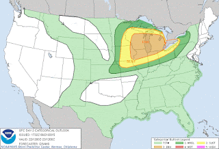
This is my preliminary post on our First Warn Blog. I am including the new images of both thecategorical severe weather outlook and the probability map. One note: the "hatched" area on the map (including ALL of us and then some) indicates the area where the SPC believes the most significant severe weather (large hail..some very large, damaging winds, and possibly some tornadoes) will be located tomorrow into tomorrow night. I will post more on this shortly. BE SURE you monitor Channel 17 ABC and/or FOX39 throughout the day tomorrow. Also, have your NOAA weather radio with tone alert (and batteries) tomorrow.// Chris Saindon 1:18 PM CDT Sunday //


Saturday, June 20, 2015

Tail cloud shot from our Skytrack Camera

Very cool shot from Skytrack! We couldn't do anything on-the-air without the hard working people
in the control room and behind the cameras. Thank you!

Shot was just before the start of our 6PM news..

ANYONE NEAR THIS CELL FROM DAVIS JUNCTION SOUTHWEST
TO DIXON..GO INDOORS AND STAY AWAY FROM WINDOWS! THIS IS
A STRONG THUNDERSTORM!

New MCD from the Storm Prediction Center

MESOSCALE DISCUSSION 1087 NWS STORM PREDICTION CENTER
NORMAN OK 0310 PM CDT SAT JUN 20 2015

 AREAS AFFECTED...CENTRAL/SOUTHERN IOWA...FAR NORTHERN MISSOURI...AND FAR WESTERN ILLINOIS

 CONCERNING...SEVERE POTENTIAL...WATCH LIKELY VALID 202010Z - 202215Z

PROBABILITY OF WATCH ISSUANCE...80 PERCENT

 SUMMARY...ELEVATED CONVECTION CONTINUES OVER EASTERN IOWA...WITH ADDITIONAL CONVECTION LIKELY TO DEVELOP ACROSS A COLD FRONT IN CENTRAL IOWA. WITH INCREASING DESTABILIZATION AND CONVECTIVE DEVELOPMENT APPEARING LIKELY TO OCCUR...A TORNADO WATCH WILL BE ISSUED BY 21Z. DISCUSSION...ELEVATED CONVECTION HAS PERSISTED ACROSS EASTERN IOWA THROUGHOUT THE DAY...PRODUCING SPORADIC INSTANCES OF MARGINALLY SEVERE HAIL AND SUB-SEVERE WIND GUSTS. TO THE WEST OF THIS CONVECTION...STRONG CAPPING AND STRONG INSOLATION HAS ALLOWED FOR A STRONGLY UNSTABLE ENVIRONMENT TO DEVELOP WITH 3000-4000 J/KG MLCAPE. VEERED SURFACE FLOW IN WESTERN PARTS OF THE DISCUSSION AREA HAVE LESSENED THE MAGNITUDE OF LOW-LEVEL SHEAR...BUT 0-3KM STORM RELATIVE HELICITY VALUES AROUND 250 M2/S2 INDICATED ON LATEST WSR-88D WIND PROFILER AT DMX SUGGESTS THE ENVIRONMENT WILL HAVE SUFFICIENT SHEAR FOR STORM ROTATION AND A TORNADO THREAT IN SURFACE BASED STORMS. LATEST HIGH-RESOLUTION MODEL GUIDANCE CONTINUES TO SUGGEST AN INCREASE IN SURFACE-BASED CONVECTION ALONG SEWD MOVING COLD FRONT IN IOWA...AND DAMAGING WINDS...SIGNIFICANT HAIL...AND TORNADOES ARE ALL POSSIBLE AS CONVECTION MATERIALIZES. A TORNADO WATCH WILL LIKELY BE ISSUED BY 21Z. ..COOK/GUYER.. 06/20/2015


This watch is just outside our viewing area -- but remain alert this evening!

Storm Track UPDATED 4:47 PM


Severe Thunderstorm Warning for Winnebago, Ogle, and De Kalb County

SEVERE THUNDERSTORM WARNING FOR...

 NORTHWESTERN DE KALB COUNTY IN NORTH CENTRAL ILLINOIS... OGLE COUNTY IN NORTH CENTRAL ILLINOIS... SOUTHWESTERN WINNEBAGO COUNTY IN NORTH CENTRAL ILLINOIS...

 * UNTIL 515 PM CDT *

AT 427 PM CDT...SEVERE THUNDERSTORMS WERE LOCATED ALONG A LINE EXTENDING FROM NEAR GERMAN VALLEY TO NEAR SHANNON...MOVING EAST AT 60 MPH.

HAZARD...60 MPH WIND GUSTS.
SOURCE...RADAR INDICATED.
 IMPACT...EXPECT DAMAGE TO ROOFS...SIDING AND TREES.

* LOCATIONS IMPACTED INCLUDE... ROCKFORD...ROCHELLE...OREGON...MOUNT MORRIS...BYRON...POLO... FORRESTON...HILLCREST...STILLMAN VALLEY...DAVIS JUNCTION... CRESTON...LEAF RIVER...ADELINE AND NEW MILLFORD. INCLUDING THE FOLLOWING INTERSTATES... I-39 BETWEEN MILE MARKERS 97 AND 115. I-88 BETWEEN MILE MARKERS 77 AND 83. THIS INCLUDES... CASTLE ROCK STATE PARK...LOWDEN STATE PARK...OGLE COUNTY FAIRGROUNDS...AND WHITE PINES STATE PARK.

PRECAUTIONARY/PREPAREDNESS ACTIONS...

 FOR YOUR PROTECTION MOVE TO AN INTERIOR ROOM ON THE LOWEST FLOOR OF A BUILDING.

Severe Thunderstorm Warning -- Stephenson County

SEVERE THUNDERSTORM WARNING FOR...
  STEPHENSON COUNTY IN NORTHWESTERN ILLINOIS...

* UNTIL 500 PM CDT

* AT 423 PM CDT...SEVERE THUNDERSTORMS WERE LOCATED ALONG A LINE
  EXTENDING FROM NEAR CEDARVILLE TO NEAR FREEPORT TO NEAR SHANNON...
  MOVING EAST AT 40 MPH.

  HAZARD...60 MPH WIND GUSTS AND PENNY SIZE HAIL.

  SOURCE...RADAR INDICATED.

  IMPACT...EXPECT DAMAGE TO ROOFS...SIDING AND TREES.

* LOCATIONS IMPACTED INCLUDE...
  FREEPORT...CEDARVILLE...DAKOTA...GERMAN VALLEY...RIDOTT...ALBERTUS
  AIRPORT...ELEROY...RIDOTT CORNERS...RED OAK...DAMASCUS...
  WINNESHIEK...SCIOTO MILLS...MC CONNELL...BOLTON...DAKOTA DORNINK
  AIRPORT AND OAKDALE NATURE PRESERVE.

PRECAUTIONARY/PREPAREDNESS ACTIONS...

FOR YOUR PROTECTION MOVE TO AN INTERIOR ROOM ON THE LOWEST FLOOR OF A
BUILDING.

TO REPORT SEVERE WEATHER CONTACT YOUR NEAREST LAW ENFORCEMENT AGENCY.
THEY WILL SEND YOUR REPORT TO THE NATIONAL WEATHER SERVICE OFFICE IN
THE QUAD CITIES .

TORRENTIAL RAINFALL IS OCCURRING WITH THESE STORMS...AND MAY LEAD TO
FLASH FLOODING. DO NOT DRIVE YOUR VEHICLE THROUGH FLOODED ROADWAYS.

Strong Storms Continue!


Remember to remain indoors away from windows when thunderstorms approach
or are occurring...

Severe Thunderstorm Warning Jo Daviess County


...A SEVERE THUNDERSTORM WARNING REMAINS IN EFFECT UNTIL 345 PM CDT FOR NORTHERN JO DAVIESS COUNTY...

AT 328 PM CDT...A SEVERE THUNDERSTORM WAS LOCATED NEAR APPLE RIVER... OR 15 MILES SOUTH OF DARLINGTON...MOVING EAST AT 45 MPH.

HAZARD...HALF DOLLAR SIZE HAIL.
SOURCE...RADAR INDICATED.
 IMPACT...DAMAGE TO VEHICLES IS EXPECTED.

 LOCATIONS IMPACTED INCLUDE... STOCKTON...WARREN...APPLE RIVER...NORA...SCHAPVILLE...APPLE CANYON LAKE AND APPLE RIVER CANYON STATE PARK. PRECAUTIONARY/PREPAREDNESS ACTIONS...

THIS STORM IS PRODUCING LARGE HAIL. SEEK SHELTER NOW INSIDE A STURDY STRUCTURE AND STAY AWAY FROM WINDOWS.

Radar Update w/Lightning Data


Heavy thunderstorms -- a few of which have been warned for high winds and hail -- are moving in from the west and northwest. I will be following them right here in the First Warn Weather Center and will keep you updated!

Chris Saindon
First Warn Meteorologist
WTVO/WQRF-TV

Friday, June 19, 2015

Update: Enhanced risk for severe weather not that far away Saturday

The quiet weather Friday will change in just a short 24 hours from now as thunderstorms move back into the Midwest.

The Storm Prediction Center has highlighted Northern Illinois and Southern Wisconsin under a slight risk for severe storms Saturday afternoon and evening, with an enhanced risk for severe weather for our southwest counties of Carroll and Whiteside. 


Storms from Friday night will be ongoing Saturday morning in Minnesota and Iowa, but are expected to fizzle out by the time they reach Northern Illinois.  As low pressure and a cold front move down from the Northern Plains during the day, a warm front will pull north into Wisconsin.  Behind the warm front will sit a very muggy and warm air mass.  Dew points Saturday afternoon could reach close to 70 degrees, making the heat index rise into the middle 90's!  This moisture will be the fuel needed for thunderstorms to develop during the afternoon and evening Saturday.

Initially, there may be a cap - or lid - on the atmosphere to prevent much growth in thunderstorms.  But by 4pm, strong to severe storms are likely in eastern Iowa ahead of the cold front.  As that front spreads east into Illinois, the severe threat shifts east as well.  Large hail, damaging winds and even an isolated tornado are all possible through Saturday evening.

Make sure to stay weather aware Saturday as storms could quickly develop late in the day.

Active weather returns to the Stateline next week


We've been able to dry out the past couple of days, and that's been nice.  But, the standing water can still be seen from the several inches of rain that fell all last week.  Unfortunately, looking ahead to next week the active weather pattern returns to the Midwest and Great Lakes.

A ridge of high pressure will build across the center of the country beginning late this weekend.  Northern Illinois and Southern Wisconsin will be on the outer edge of the ridge, leaving a direct path for active storm systems.  The first of those systems arrives late Saturday, with strong to severe storms likely.  After that, thunderstorms roll back into the picture Sunday night and remain in the 7-day forecast straight through the end of next week.  Just like last week, the days won't be complete washouts, but the daily storm threat will remain.