 This year's outlook is almost an exact reversal of last year's outlook. In terms of temperatures this winter, areas of the south will experience a 30-60% chance of above average temperatures, including most of the western U.S and the southern Plains. While portions of Montana, the Northern Plains, Minnesota, and Wisconsin have a 30-40% probability of experiencing below average temperatures. The Stateline area right now is on track for an average winter in terms of chilly conditions.
 On the snowy/precipitation side of things, again areas in the west and south have a 30-50% probability of experiencing a drier winter. While those around the Great Lakes and Northwest have about a 30-40% probability of a wetter winter ahead.
When we say winter, we mean meteorological winter which includes December, January, and February.
But as mentioned above the outlook is almost the reverse of last year's winter outlook, but why? The reason: A transition from El Niño to La Niña. Last year featured a very strong El Niño, which is the warm phase of something called the El Niño Southern Oscillation (also known as ENSO). El Nino is generated by or associated with an area of warm ocean water that develops in the central equatorial Pacific Ocean. La Niña is the opposite of this, and is formed when there are cooler temperatures in the Pacific.
This year there is a La Niña Watch for the fall, with a 70% chance that a La Niña will develop. But, confidence is low in this feature lasting through the winter. There is only a 55% chance that it will last through the winter months.
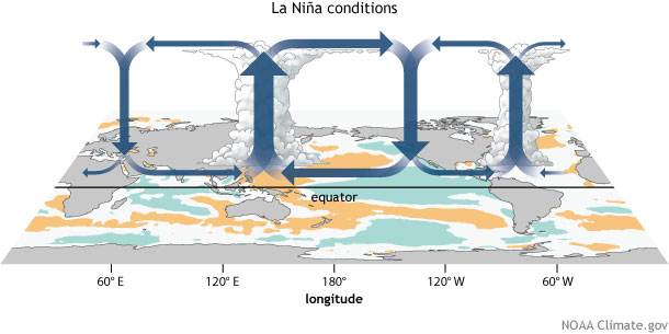
Not only does this climate phenomenon correlate to ocean temperatures, but it also requires action in the atmosphere as well. During a La Niña event, the ocean surface in the equatorial regions of the Pacific are cooler than normal. This leads to sinking air and less rain in that region, in turn the waters near Indonesia get warmer and in turn cause rising air and more rain.

Generalized Walker Circulation (December-February) anomaly during La
Niña events, overlaid on map of average sea surface temperature
anomalies. Anomalous ocean cooling (blue-green) in the central and
eastern Pacific Ocean and warming over the western Pacific Ocean enhance
the rising branch of the Walker circulation over the Maritime Continent
and the sinking branch over the eastern Pacific Ocean. Enhanced rising
motion is also observed over northern South America, while anomalous
sinking motion is found over eastern Africa. NOAA Climate.gov drawing by
Fiona Martin.
Here's a great depiction of this circulation from the National Climate Prediction Center:
Here's a great depiction of this circulation from the National Climate Prediction Center:
If you'd like to read more about ENSO click here.
As stated in previous articles, just because there a 50/50 chance, of 'average' temperatures expected for our area doesn't mean that we still won't experience mild temperatures and arctic cold snaps at times this winter, these outlooks indicate patterns we look to see and the winter as a whole over the three months. Same goes for any rain or snowy conditions. Just because we could see more snow this year does not mean that there will be extremely large snow events, it just indicates that some climate factors point to there being a more active pattern this winter, thus leading to more snow.
We just want to make sure you are prepared for all sorts of winter weather this year! We live in the Midwest so we can expect cold temperatures and snowfall this winter!

No comments:
Post a Comment